
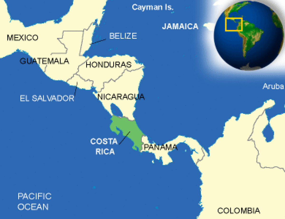
Where is Costa Rica located?
What countries border Costa Rica?
Costa Rica Weather
What is the current weather in Costa Rica?
Costa Rica Facts and Culture
What is Costa Rica famous for?
- Cultural Attributes: People generally work in order to secure financial stability. Getting a car and/or a house is the main goal... More
- Family: Extended family is the basis of society. Several generations may live in the same house. Visiting relatives is important and... More
- Personal Apperance: Western style clothing is worn. Clean, unwrinkled clothing is very important to urban working class. Generally jeans and shirts for... More
- Recreation: Football(soccer) is the national sport. Children will normally play it at school, but they also play it in parks... More
- Diet: Vigorón is a dish imported for Nicaragua, Costa Rica's neighbor country. More
- Food and Recipes: Breakfast and "morning coffee" vary depending on the person with the latest eating time about 10.30 a.m. Lunch is had... More
- Visiting: "Personal space" of about 40 cm of distance between two people during conversation is common. Eye contact should be... More
Costa Rica Facts
What is the capital of Costa Rica?
| Capital | San Jose |
| Government Type | presidential republic |
| Currency | Costa Rican colones (CRC) |
| Total Area |
19,730 Square Miles 51,100 Square Kilometers |
| Location | Central America, bordering both the Caribbean Sea and the North Pacific Ocean, between Nicaragua and Panama |
| Language | Spanish (official), English |
| GDP - real growth rate | 4.3% |
| GDP - per capita (PPP) | $16,100.00 (USD) |
Costa Rica Demographics
What is the population of Costa Rica?
| Ethnic Groups | white (including mestizo) 94%, black 3%, Amerindian 1%, Chinese 1%, other 1% |
| Nationality Noun | Costa Rican(s) |
| Population | 5,097,988 |
| Population Growth Rate | 1.27% |
| Population in Major Urban Areas | SAN JOSE (capital) 1.515 million |
| Urban Population | 64.700000 |
Costa Rica Government
What type of government does Costa Rica have?
| Executive Branch |
chief of state: President Rodrigo CHAVES Robles (since 8 May 2022); First Vice President Stephan BRUNNER Neibig (since 8 May 2022); Second Vice President Mary Denisse MUNIVE Angermuller (since 8 May 2022); note - the president is both chief of state and head of government head of government: President Rodrigo CHAVES Robles (since 8 May 2022); First Vice President Stephan BRUNNER Neibig (since 8 May 2022); Second Vice President Mary Denisse MUNIVE Angermuller (since 8 May 2022) cabinet: Cabinet selected by the president elections/appointments: president and vice presidents directly elected on the same ballot by modified majority popular vote (40% threshold) for a 4-year term (eligible for non-consecutive terms); election last held on 6 February 2022 with a runoff on 3 April 2022 (next to be held in February 2026 with a runoff in April 2026) election results: 2022: Rodrigo CHAVES Robles elected president in second round; percent of vote in first round - Jose Maria FIGUERES Olsen (PLN) 27.3%, Rodrigo CHAVES Robles (PPSD) 16.8%, Fabricio ALVARADO Munoz (PNR) 14.9%, Eliecer FEINZAIG Mintz (PLP) 12.4%, Lineth SABORIO Chaverri (PUSC) 12.4%, Jose Maria VILLALTA Florez-Estrada 8.7% (PFA), other 7.5%; percent of vote in second round - Rodrigo CHAVES Robles (PPSD) 52.8%, Jose Maria FIGUERES Olsen (PLN) 47.2% 2018: Carlos ALVARADO Quesada elected president in second round; percent of vote in first round - Fabricio ALVARADO Munoz (PRN) 25%; Carlos ALVARADO Quesada (PAC) 21.6%; Antonio ALVAREZ (PLN) 18.6%; Rodolfo PIZA (PUSC) 16%; Juan Diego CASTRO (PIN) 9.5%; Rodolfo HERNANDEZ (PRS) 4.9%, other 4.4%; percent of vote in second round - Carlos ALVARADO Quesada (PAC) 60.7%; Fabricio ALVARADO Munoz (PRN) 39.3% |
| Suffrage | 18 years of age; universal and compulsory |
| Citizenship |
citizenship by birth: yes citizenship by descent only: yes dual citizenship recognized: yes residency requirement for naturalization: 7 years |
| National Holiday | Independence Day, 15 September (1821) |
| Constitution |
history: many previous; latest effective 8 November 1949 amendments: proposals require the signatures of at least 10 Legislative Assembly members or petition of at least 5% of qualified voters; consideration of proposals requires two-thirds majority approval in each of three readings by the Assembly, followed by preparation of the proposal as a legislative bill and its approval by simple majority of the Assembly; passage requires at least two-thirds majority vote of the Assembly membership; a referendum is required only if approved by at least two thirds of the Assembly; amended many times, last in 2020 |
| Independence | 15 September 1821 (from Spain) |
Costa Rica Video
YouTube, Jacob + Katie Schwarz Costa Rica Nature
CountryReports YouTube Channel:
Join CountryReports YouTube Channel (Click Here)Costa Rica Geography
What environmental issues does Costa Rica have?
| Overview |
At 19,730 square miles, about four-fifths the size of West Virginia, Costa Rica is, with the exception of El Salvador and Belize, the smallest country in Central America. It is bounded on the North and Southeast by Nicaragua and Panama, respectively; on the East by the Caribbean Sea; and on the West and South by the Pacific Ocean. Limon, the major Caribbean port, is 2,400 miles from New York; Puerto Caldera, the principal Pacific port, is located 2,700 miles from San Francisco. A rugged central massif runs the length of the country, north to south, separating the coastal plains. Even though Costa Rica lies totally within the tropics, the range of altitudes produces wide climatic variety. The country has four distinct geographic regions: The Caribbean Lowlands are hot and humid, and comprise about one-fourth of the total area of Costa Rica. It is the major banana-exporting region. The lowlands contain less than 10 percent of the population. The Highlands are the economic, political, and cultural heart of the country, and include the Central and Talamanca mountain ranges and the Meseta Central where the capital, San Jose, is located. The Meseta, with elevations ranging from 3,000 to 4,500 feet, and adjacent areas contain nearly two-thirds of Costa Rica’s population. The region has rolling, well-drained land, productive soil, and pleasant sub-tropical temperatures, with an annual rainfall of 60-75 inches. The central highlands have most of Costa Rica's improved roads, and there is direct access to both coasts by paved highway and air. The Guanacaste Plains comprise the rolling section of northwest Costa Rica, and include portions of the provinces of Guanacaste and Puntarenas, plus the Nicoya Peninsula. Despite having the lowest average annual rainfall and the longest dry season, the region is important for agriculture and livestock production as well as a popular area for tourism. The area contains 15 percent of Costa Rica’s population. Southern Costa Rica is the wettest part of Costa Rica with some 10 percent of the population. San Jose, with a metropolitan population of over one million, is almost completely surrounded by mountains, and just a few minutes’ drive from the center of the city are foothills that offer a country atmosphere and lovely views. The central part of the capital is divided into four quadrants by Avenida Central running east and west, and Calle Central running north and south. The arrangement of streets is logical, but initially confusing: Odd-numbered avenues (avenidas) are located north of Avenida Central and even-numbered avenues are to the south; odd-numbered streets (calles) are east of Calle Central, and even-numbered streets are to the west. Street names or numbers are seldom used. Locations are given in relation to some landmark that may, or may not, be well known, such as a public building, a monument, a prominent intersection, or even a grocery store or gasoline station. Distances are expressed in meters (“metros” in Spanish), and 100 meters is roughly equivalent to a normal city block. At times, the point of reference is a landmark that once existed but no longer is standing, a practice that works for long-time residents of San Jose but generally adds to the considerable confusion. Most city streets in San Jose are paved, but many are narrow and rough, and congestion and noise are constant problems in the city. The pollution at times can be stifling. Potholes are a constant threat to the unwary, both in the city and in the countryside, and often are deep enough to damage vehicles. Open manholes are a danger as well, since theft of manhole covers seems to be a favorite activity in San Jose. Downtown commercial buildings usually have two or three stories, but newer structures are much taller. Residential sections have many modern homes of brick, wood, or concrete construction, with either tile or galvanized metal roofs. Large one-story or two-story residences are found in the suburbs where Embassy employees live. Parks of all sizes are located throughout the city. |
| Climate |
Altitude determines the climate throughout Costa Rica. Areas below 3,000 feet have average annual temperatures of around 80°, with little variation from month to month. The temperature drops from around 74° at 3,000 feet to 59 degrees at 5,000 feet. Above 5,000 feet, the average annual temperatures can range as low as 40 degrees to the mid-50s, with occasional frost during the coolest months. The temperature in San Jose is generally pleasant, with two seasons distinguished mainly by the rainfall. The dry season runs from December through April and the wet season extends from May through November. Even during the wet season the mornings generally are clear, with the afternoons and evenings dominated by heavy rains nearly every day. Relatively high winds often are present during the dry season. The average temperature in San Jose is 70 to 75° Fahrenheit. In December, the coolest month, the average temperature drops to around 65°. Temperatures drop into the 50s at night throughout the year. Humidity in San Jose averages 80 percent annually.
|
| Border Countries | Nicaragua 309 km, Panama 330 km |
| Environment - Current Issues | deforestation and land use change, largely a result of the clearing of land for cattle ranching and agriculture; soil erosion; coastal marine pollution; fisheries protection; solid waste management; air pollution |
| Environment - International Agreements | party to: Biodiversity, Climate Change, Climate Change-Kyoto Protocol, Desertification, Endangered Species, Environmental Modification, Hazardous Wastes, Law of the Sea, Marine Dumping, Ozone Layer Protection, Wetlands, Whaling signed, but not ratified: Marine Life Conservation |
| Terrain | coastal plains separated by rugged mountains including over 100 volcanic cones, of which several are major volcanoes |
Costa Rica Economy
How big is the Costa Rica economy?
| Economic Overview |
Since 2010, Costa Rica has enjoyed strong and stable economic growth - 3.8% in 2017. Exports of bananas, coffee, sugar, and beef are the backbone of its commodity exports. Various industrial and processed agricultural products have broadened exports in recent years, as have high value-added goods, including medical devices. Costa Rica's impressive biodiversity also makes it a key destination for ecotourism. Foreign investors remain attracted by the country's political stability and relatively high education levels, as well as the incentives offered in the free-trade zones; Costa Rica has attracted one of the highest levels of foreign direct investment per capita in Latin America. The US-Central American-Dominican Republic Free Trade Agreement (CAFTA-DR), which became effective for Costa Rica in 2009, helped increase foreign direct investment in key sectors of the economy, including insurance and telecommunication. However, poor infrastructure, high energy costs, a complex bureaucracy, weak investor protection, and uncertainty of contract enforcement impede greater investment. Costa Rica’s economy also faces challenges due to a rising fiscal deficit, rising public debt, and relatively low levels of domestic revenue. Poverty has remained around 20-25% for nearly 20 years, and the government’s strong social safety net has eroded due to increased constraints on its expenditures. Costa Rica’s credit rating was downgraded from stable to negative in 2015 and again in 2017, upping pressure on lending rates - which could hurt small business, on the budget deficit - which could hurt infrastructure development, and on the rate of return on investment - which could soften foreign direct investment (FDI). Unlike the rest of Central America, Costa Rica is not highly dependent on remittances - which represented just 1 % of GDP in 2016, but instead relies on FDI - which accounted for 5.1% of GDP. |
| Industries | medical equipment, food processing, textiles and clothing, construction materials, fertilizer, plastic products |
| Currency Name and Code | Costa Rican colones (CRC) |
| Export Partners | US 33.6%, China 6.2%, Mexico 4.6%, Nicaragua 4.3%, Netherlands 4.2%, Guatemala 4% |
| Import Partners | US 45.3%, China 9.8%, Mexico 7.1% |
Costa Rica News and Current Events
What current events are happening in Costa Rica?
Source: Google News
Costa Rica Travel Information
What makes Costa Rica a unique country to travel to?
Country Description
Costa Rica is a middle-income, developing country with a strong democratic tradition. Tourist facilities are generally adequate. While English is a second language for many Costa Ricans in tourist areas, knowledge of Spanish is necessary for legal matters and in non-tourist areas.
Crime
Crime is a significant concern for Costa Ricans and visitors alike, and the Embassy reports a steady increase in crime. While the vast majority of foreign visitors do not become victims of crime, all are potential targets for criminals. Criminals usually operate in small groups, but may also operate alone. The most common crime perpetrated against tourists is theft, with thieves primarily looking for cash, jewelry, credit cards, electronic items and passports. Serious crimes, although less frequent, do occur. At least 7 U.S. citizens have been murdered in Costa Rica since January 2012. Daytime robberies in public places occur, and thieves are often armed and may resort to violence. Since January 2012, 21 U.S. citizens have reported to the Embassy that they were sexually assaulted, with at least six victims reporting that they were given date rape drugs. While the Costa Rican police claim to investigate all reported cases of rape, there have been no convictions in sexual assault cases of U.S. citizens since January 2012. .While crimes occur throughout Costa Rica, they are more prevalent at certain times and in certain areas. The downtown area of San Jose for example, is a prime tourist destination during daylight hours. You are strongly encouraged, however, not to go there after dark. U.S. government officials, in fact, are not permitted to stay in hotels in that area due to safety concerns. U.S. Embassy San Jose has received reports of a particularly high number of violent assaults and robberies in the Limon Caribbean costal region (from Tortuguero through Limon to Puerto Viejo), often involving invasions of rental homes and ecolodges, as well as attacks taking place on isolated roads and trails. If you plan to visit an unfamiliar area, you should consult with a trustworthy local (a concierge, a tour guide, etc.) regarding precautions or concerns.
Thieves often work in groups to set up a victim. A prevalent scam involves the surreptitious puncturing of tires of rental cars, often near restaurants, tourist attractions, airports, or close to the car rental agencies themselves. When the travelers pull over, "good Samaritans" quickly appear to help change the tire - and just as quickly remove valuables from the car, sometimes brandishing weapons. Drivers with flat tires are advised to drive, if at all possible, to the nearest service station or other public area and change the tire themselves, watching valuables at all times. Another common scam involves one person dropping change in a crowded area, such as on a bus. When the victim tries to assist, a wallet or other item is taken.
Take proactive steps to avoid becoming a crime victim. Do not walk, hike or exercise alone, and bear in mind that crowded tourist attractions and resort areas popular with foreign tourists are common venues for criminal activity. Ignore any verbal harassment, and avoid carrying large amounts of cash, jewelry, or expensive photographic equipment. You should be particularly cautious of walking alone at night and should not leave bars or restaurants with strangers. Additionally, do not seek entertainment in groups of people you do not know. Do not consume food or drinks you have left unattended, or accept food or drinks from "friendly" people. Costa Rican immigration authorities conduct routine immigration checks at locations such as bars in downtown San Jose and beach communities. U.S. citizens questioned during these checks who have only a copy of the passport may be asked to provide the original passport with appropriate stamps. Be sure you are certain of the location of your passport and will have ready access to it.
Travelers renting vehicles should purchase an adequate level of locally valid theft insurance, park in secure lots whenever possible, and never leave valuables in their vehicles. Please note that there are unlicensed “parking attendants” that will occasionally assist you in parking; however, parking where they indicate does not always guarantee that it is a legal parking spot. Drivers should be cautious of where they park their cars. The U.S. Embassy receives several reports daily of valuables, identity documents, and other items stolen from locked vehicles, primarily rental cars. Thefts from parked cars can occur nearly anywhere, although cities, beaches and coastal towns, the airport, in front of restaurants and hotels, and national parks and other tourist attractions are common locations.
U.S. government personnel are not permitted to travel on city buses due to safety concerns, and must use caution when traveling on any other buses. If you choose to travel by bus, you are encouraged to keep your bag with valuables and identification on your lap. Personal items are frequently stolen from buses. Do not store your bags or other personal belongings in the storage bins, as theft from overhead bins is common. You should keep your belongings in your line of sight at all times and your valuables in your possession. If you choose to help another passenger stow his belongings, you should be especially cautious that your own belongings are not being removed while you are doing so.
Travelers should use only licensed taxis, which are typically red with medallions (yellow triangles containing numbers) painted on the side. Licensed taxis at the airport are painted orange. All licensed taxis should have working door handles, locks, seatbelts and meters (called "marias"); passengers are encouraged to use seatbelts.
Don’t buy counterfeit and pirated goods, even if they are widely available. Not only are the bootlegs illegal in the United States, if you purchase them you may also be breaking local law.
Criminal Penalties
While you are traveling in Costa Rica, you are subject to its laws and regulations even if you are a U.S. citizen. Some laws in Costa Rica differ significantly from those in the United States and may not afford the protections available to the individual under U.S. law. Penalties for breaking the law can be more severe than in the United States for similar offenses. Persons violating Costa Rica’s laws, even unknowingly, may be expelled, arrested or imprisoned. The law permits pre-trial detention of persons accused of serious crimes. Penalties for possession, use, or trafficking in illegal drugs in Costa Rica are severe, and convicted offenders can expect long jail sentences and heavy fines. Engaging in sexual conduct with minors or using or disseminating child pornography in a foreign country is a crime, prosecutable in the United States. It is also a crime in Costa Rica. Foreign laws and legal systems can be vastly different than our own. Driving under the influence of alcohol or drugs could land you immediately in jail. You can be prosecuted under U.S. law if you buy pirated goods. If you break local laws in Costa Rica, your U.S. passport will not help you avoid arrest or prosecution. It is very important to know what is legal and what is not where you are going.If you are arrested in Costa Rica, authorities are required to notify the U.S. Embassy of your arrest. If you are concerned the Department of State may not be aware of your situation, you should request the police or prison officials to notify the U.S. embassy of your arrest.
Medical Facilities and Health Information
Costa Rica actively promotes medical tourism. While the perceived advantages are affordable costs, quality health care, and a chance to recuperate and have a vacation at the same time, there are also risks.Medical tourists should confirm that the facilities they intend to use are accredited and have an acceptable level of care. They should also purchase medical evacuation insurance before travelling, and should confirm that the cost and payment for their treatment is clearly understood by both parties. Persons with unpaid or disputed debts in Costa Rica may be legally prevented from leaving the country.
In the event of unforeseen medical complications or malpractice, medical tourists may not be covered by their personal insurance or may not be able to seek damages through malpractice lawsuits. Although many hospitals and clinics abroad have medical malpractice insurance, seeking compensation can prove to be difficult because insurance laws and legal options may not exist. Be aware that if you should need or wish to be transferred to a hospital in the United States and do not have medical evacuation insurance, an air ambulance flight can cost upwards of US$20,000 and will often take place only after you (or your loved ones) have paid for it.
Medical care in San Jose is generally adequate, but is limited in areas outside of San Jose. Most prescription and over-the-counter medications are available throughout Costa Rica. Doctors and hospitals often expect immediate cash payment for health services, and U.S. medical insurance is not always valid outside the United States. A list of local doctors and medical facilities can be obtained from the U.S. Embassy in San Jose’s website.. An ambulance may be summoned by calling 911. Most ambulances provide transportation but little or no medical assistance.
Malaria can occur in some rural locations, but is not commonly encountered. However, Costa Rica regularly experiences outbreaks of dengue fever in much of the country. Unlike some of the other mosquito-borne illnesses, there is no medical prophylactic or curative regimen for dengue. Travelers should take precautions against being bitten by mosquitoes to reduce the chance of contracting the illness, such as avoiding standing water, wearing long sleeves and pants in both day and night, and applying insect repellent regularly. On July 2, 2013, the Ministry of Health declared a health alert due to the increase in cases of dengue.
Safety and Security
The incidence of crime in Costa Rica is higher than in many parts of the United States and has adversely affected the traveling public. Pickpocketing and theft remain the most common crimes perpetrated against tourists, with theft from vehicles or on buses being particularly frequent. U.S. citizens also have been the victims of violent crime, including sexual assaults, robberies, car-jackings and murders. Armed robberies can occur even in daylight on busy streets. U.S. citizen tourists and residents can, however, take steps to protect themselves. You should exercise at least the same level of caution in Costa Rica that you would in major cities or tourist areas in the United States. Engaging in high-risk behavior, such as excessive consumption of alcohol or drugs, can increase the vulnerability of an individual to accidents or opportunistic crime.Demonstrations in Costa Rica generally are peaceful. However, demonstrators in Costa Rica have been known to block traffic on roads or disrupt travel, causing inconvenience to tourists. Visitors to Costa Rica may also be inconvenienced by infrequent work stoppages and strikes. The Costa Rica Constitution prohibits political activity by foreigners; such actions may result in detention and/or deportation. Travelers should avoid political demonstrations and other activities that might be deemed political by the Costa Rican authorities. U.S. citizens are urged to exercise caution if in the vicinity of any protests.
There have been no recent acts of terrorism in Costa Rica.
Beach conditions warning: On both the Caribbean and Pacific coasts, currents are swift and dangerous, and the majority of dangerous beaches have neither lifeguards nor warning signs. According to the Costa Rican Red Cross, approximately 59 people drowned in 2012 in Costa Rica due to treacherous rip currents. These rip currents have swept even strong swimmers out to sea. Visitors should carefully consider the safety of any beach before entering the water. There have been reports that beachside hotels have removed signs warning against dangerous swimming conditions for fear that they may lose business. U.S. citizens are urged to always exercise extreme caution when swimming in the ocean and to never swim alone. Eleven U.S. citizens drowned in Costa Rica in the last year. Crocodile sightings have also been reported along beaches, including those popular with swimmers and surfers.
There are many scenic areas in Costa Rica where a small incident may become life-threatening due to the rugged terrain or remote location. Foreign visitors, including one U.S. citizen, have disappeared while hiking or traveling in Costa Rica. Extreme caution, whether swimming, hiking, or driving, is advised. Adventure tourism is popular in Costa Rica, and many companies offer white-water rafting, bungee jumping, jungle canopy tours, SCUBA diving, and other outdoor activities. U.S. citizens are urged to use caution in selecting adventure tourism companies. Although the Costa Rican government regulates most of these companies and local regulations require they meet certain safety standards and have insurance coverage, there is not uniform and effective enforcement of these regulations. Even where strictly enforced, safety measures may not be as stringent or as comprehensive as what you may be familiar with in the United States. Visitors have been injured or even killed due to improper, careless, or reckless operation of scooters, jet-skis, quads, and other recreational equipment. You should rent equipment only from reputable operators, use all appropriate safety gear, and insist on sufficient training before using the equipment. In addition, travelers to remote or isolated scenic venues should be aware that they may be some distance from appropriate medical services, law enforcement, ATMs, , or consular assistance in an emergency. The Costa Rican Tourism Institute (ICT) website has contact information for licensed tour operators and travel agencies.
Traffic Safety and Road Conditions
While in Costa Rica, you may encounter road conditions that differ significantly from those in the United States. The information below concerning Costa Rica is provided for general reference only, and may not apply to a particular location or circumstance.Roads are often in poor condition. Large potholes with the potential to cause significant damage to vehicles are common. Traffic signs, even on major highways, are inadequate and few roads have clearly marked lanes. Except for the principal highways, few roads have names, making it difficult to find addresses. Shoulders are narrow or consist of drainage ditches. Visibility at intersections is often limited by hedges or other obstacles. Bridges, even on heavily traveled roads, may be only a single lane requiring vehicles traveling in one direction to cede the right of way to oncoming vehicles. Pedestrians, cyclists, and farm animals are common sights along or on main roads, creating additional potential driving hazards. Buses and cars frequently stop in travel lanes, even on expressways. Traffic laws and speed limits are often ignored, turn signals are rarely used, passing on dangerous stretches of highway is common, and pedestrians are not given the right of way. The abundant motorcyclists, in particular, drive without respect to rules of the road, often passing on the right, weaving in and out without warning, and creating lanes where none officially exist. As a result, the fatality rate for pedestrians and those riding bicycles and motorcycles is disproportionately high. All of the above, in addition to poor visibility due to heavy fog or rain, can make driving treacherous. Landslides are common in the rainy season. Main highways and principal roads in the major cities are paved, but some roads to beaches and other rural locations are not. Additionally, rural roads sometimes lack bridges, and motorists are compelled to ford waterways; you should exercise extreme caution in driving across moving water, as a small trickle in the dry season may become a strong torrent after a heavy rain upstream. Even a few inches of moving water may be sufficient to float your vehicle, and the river bed may not be stable.
In order to drive in Costa Rica, drivers need to show a valid U.S. driver’s license or an international driving permit. Drunk driving is illegal in Costa Rica. Driving while using a cell phone is illegal. As mentioned above, visitors contemplating driving in Costa Rica should carefully consider the implications of not being allowed to depart the country for many months or longer in the event of a vehicular accident. Additionally, fines for routine traffic violations can be upwards of $500.00. U.S. citizens have occasionally reported to the Embassy that charges for unpaid traffic tickets have appeared on the credit card that was on file with the rental car company. The Embassy cannot intervene in such cases and can generally only refer citizens to the rental car company representatives and to a list of attorneys maintained on the Embassy website.
Many destinations are accessible only with high clearance, four-wheel drive vehicles. When staying outside of urban areas, travelers should call ahead to their hotels to ask about the current status of access roads. Travelers should also minimize driving at night, especially outside of urban areas.
Costa Rica has a 911 system for reporting emergencies. In the event of a traffic accident, vehicles must be left where they are and should not be moved from where the accident occurred. Both the traffic police and an insurance investigator must make accident reports before the vehicles are moved.