
 English
 Español
 中文
中文 हिन्दी
 Français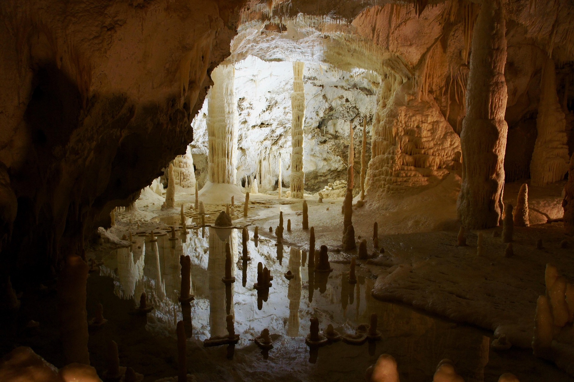
Caves and Underground Wonders of the World
comprehensive guide to the world's greatest cave systems underground rivers and subterranean wonders
Introduction: Into the Earth
Beneath the surface of every continent, hidden from sunlight and outside the normal rhythms of the human world, lies a realm of extraordinary complexity and beauty. Caves — natural underground voids large enough to accommodate a human body — represent one of the most diverse and least understood environments on Earth. They are carved by water, shaped by fire, sculpted by ice, and haunted by the ghosts of species that have never known the light of day. From the cathedral passages of Mammoth Cave in the United States to the jungle-roofed chambers of Hang Son Doong in Vietnam, from the frozen labyrinths beneath the Austrian Alps to the sacred grottos of ancient India, the underground world is a frontier that has fascinated explorers, scientists, artists, and spiritual seekers for as long as human beings have walked upon the surface of the planet.
Caves are not merely geological curiosities. They are archives. Their walls preserve paintings made by Paleolithic hunters thirty-six thousand years ago. Their floors hold the bones of extinct megafauna, the artifacts of vanished cultures, and the mineral records of ancient climates. Their waters carry entire ecosystems of organisms that have evolved over millions of years in absolute darkness, developing forms so alien to surface life that they once seemed like creatures from mythology. Their atmospheres, stable and unchanging across centuries, have sheltered human beings from persecution, cold, and war. The study of caves — speleology — sits at the intersection of geology, hydrology, biology, archaeology, climatology, and adventure in a way that few disciplines can match.
The science of speleology takes its name from the Greek spelaion, meaning cave, and logos, meaning study. Though human beings have explored caves for practical purposes — shelter, food storage, religious ritual, and mining — since prehistoric times, speleology as a formal discipline emerged only in the late nineteenth century. The French explorer Edouard-Alfred Martel is widely credited as the father of modern speleology, having descended dozens of caves across Europe in the 1880s and 1890s with scientific instruments and systematic intent. His investigations in the Causses region of southern France, in the Pyrenees, and eventually in caves across a dozen countries established the methods that speleologists still refine today. Since Martel's era, the science has grown enormously, encompassing cave diving, remote sensing, DNA analysis of cave organisms, and the use of lidar technology to produce three-dimensional maps of passages that would take centuries to survey by hand.
To understand why caves exist, one must understand how they form. Geologists recognize several distinct types of caves, each shaped by different processes and occurring in different rock types and landscapes. The most common and most extensive caves worldwide are solutional caves, also called karst caves, formed when slightly acidic water dissolves soluble rock over geological timescales. Rainwater absorbs carbon dioxide from the atmosphere and from soil, forming weak carbonic acid. As this water percolates down through fractures and bedding planes in limestone, dolomite, or marble, it slowly dissolves the calcium carbonate in the rock. Over thousands to millions of years, small seeps become trickles, trickles become streams, and streams carve passages of ever-increasing size. The landscape left behind — riddled with sinkholes, springs, disappearing streams, and cave entrances — is called karst terrain, a name derived from the Kras Plateau in Slovenia, where this type of landscape was first scientifically described. Approximately fifteen percent of the Earth's land surface is underlain by soluble rocks capable of forming karst, and virtually all of the world's longest and deepest cave systems occur within these rocks.
A second major type, lava tubes, forms through an entirely different mechanism. When basaltic lava flows rapidly down a slope, the outer surfaces of the flow cool and solidify while molten lava continues to move beneath. When the eruption feeding the flow ceases, the molten interior drains away, leaving behind a hollow tube. Lava tubes can be extraordinarily long — the Kazumura Cave on the island of Hawaii stretches more than sixty-five kilometers — and they form rapidly by geological standards, sometimes in a matter of days or weeks. Their walls are often smooth and glassy, and they frequently preserve features such as lava benches, stalactite-like lava drips, and the preserved marks of successive lava levels.
Sea caves form along coastlines where wave action exploits weaknesses in cliff faces, steadily hammering away at the rock until chambers and passages develop behind the cliff face. The Blue Grotto of Capri, Italy, is among the most celebrated examples, its brilliant azure light the result of sunlight entering through an underwater opening and refracting through the water. Fracture caves form in any hard rock where tectonic movements have opened joints or fault planes wide enough for human passage. Glacier caves and ice caves — distinct phenomena that are frequently confused — form either within glacial ice itself or within rock caves where water freezes and persists year-round because of the movement of cold air. The Eisriesenwelt in Austria and the ice caves of Iceland's Vatnajokull glacier represent two of the most spectacular examples of these frozen underworlds.
Regardless of how they form, all caves share certain physical characteristics that distinguish them from the surface world. Temperature within caves is remarkably stable, hovering near the mean annual surface temperature for the region — roughly ten degrees Celsius in the temperate caves of central Europe, and approaching thirty degrees or more in tropical limestone systems near the equator. Humidity is typically very high, often near one hundred percent, except in desert caves or in caves with strong air circulation. Light is absent beyond the first few meters of a cave entrance, meaning that every organism found deep within a cave must either bring its energy in from outside or derive it from chemical reactions rather than sunlight.
Cave formations — technically called speleothems — develop wherever water carrying dissolved minerals drips, seeps, or flows through the cave environment. The most familiar are stalactites, which grow downward from ceilings as calcium-rich water evaporates and deposits calcite, and stalagmites, which build up from the floor where dripping water lands. When a stalactite and stalagmite meet, they form a column. But the variety of speleothems extends far beyond these familiar forms. Helictites twist in directions that seem to defy gravity. Cave pearls form in the splash zones of dripping water, building concentric layers of calcite around a tiny nucleus. Cave popcorn and moonmilk coat cave walls in textures that seem more biological than mineral. Gypsum flowers curl in elegant spirals from walls and ceilings in dry desert caves. The Crystal Cave beneath the Naica mine in Chihuahua, Mexico, contains selenite crystals up to eleven meters long — among the largest natural mineral formations ever discovered on Earth.
Cave ecosystems represent a separate and entirely distinct dimension of the underground world. Because sunlight cannot penetrate beyond the entrance zone, the deep cave environment is a food-energy-limited system in which every calorie ultimately derives from outside the cave. Organic matter — leaf litter, dead insects, dung from bat colonies, flood-carried debris — provides the energetic foundation for cave food webs. In some remarkable systems, chemolithotrophic bacteria derive energy directly from the oxidation of sulfur compounds or iron, bypassing the solar energy chain entirely and creating what are called chemoautotrophic ecosystems. The Lechuguilla Cave in New Mexico and the Movile Cave in Romania are among the best-documented examples of caves where life thrives on chemical energy alone.
The organisms that live permanently in the deep cave environment — called troglobites or stygobites if they live in water — show a suite of adaptations that have captivated biologists since Darwin's era. Eyes, which are metabolically expensive to maintain and useless in the dark, are reduced or absent in many cave species. Pigmentation, equally unnecessary without light, is typically lost, giving cave animals their characteristic pallid or translucent appearance. In their place, sensory systems sensitive to vibration, water pressure, and chemical gradients are often greatly enhanced. Cave fish locate prey by detecting the tiny pressure waves of moving water. Cave spiders sense the vibrations of prey on their webs across distances that would be impossible in surface-dwellers. These adaptations, reached independently by hundreds of separate lineages across the world's caves, represent one of the most powerful natural experiments in convergent evolution that biology has to offer.
The World's Longest Cave Systems
The measurement of cave length is a precise and painstaking science. Survey teams equipped with compasses, inclinometers, and laser rangefinders map every passage, crawlway, and chamber, recording each measurement to the nearest centimeter and compiling the data into three-dimensional models of underground topography. Even with modern technology, mapping a major cave system requires hundreds or thousands of person-hours spread across decades of expeditions. New passages are discovered regularly, and the official measured lengths of the world's longest caves are updated every few years as exploration continues.
The undisputed champion of cave length is Mammoth Cave, located within Mammoth Cave National Park in the state of Kentucky in the United States. As of 2024, more than 426 miles — approximately 686 kilometers — of surveyed passageways have been mapped within the Mammoth Cave system, making it more than twice as long as any other known cave on Earth. Yet even this extraordinary figure likely represents only a fraction of the system's true extent. Explorers with the Cave Research Foundation, which has been mapping Mammoth Cave since the late 1950s, add new miles of passages regularly, and hydrological evidence suggests that the cave's drainage basin extends far beyond currently explored regions. The cave has been known to local inhabitants since at least the late eighteenth century and was mined for calcium nitrate, used in gunpowder manufacture, during the War of 1812. Its extraordinary length is a function of its geology: the cave lies within the Pennyroyal Plain of central Kentucky, a region of nearly flat-lying Mississippian-age limestone about 330 million years old, dissected by the Green River drainage system over the past several million years. Each time the river eroded deeper into the valley, the water table fell and the cave passages that had been carved at the previous water level were abandoned, eventually being recognized as separate levels of an interconnected system. Today, Mammoth Cave is known to have at least five distinct levels, separated by sandstone and shale beds that protected the limestone above from collapse while the lower levels were being carved.
The passages of Mammoth Cave range from vast corridors called avenues — some more than fifteen meters wide and ten meters high, their ceilings stained with centuries of lamp smoke from early visitors — to tight crawlways barely large enough for a determined caver to squeeze through. The cave contains nearly every speleothem type known, including gypsum flowers, cave popcorn, selenite crystals, calcite rafts floating on still pools, and cave balloons — transparent bubbles of hydromagnesite so delicate that a breath of air will collapse them. It harbors over 130 species of cave animals, including the Kentucky cave shrimp, one of the most endangered invertebrates in North America, and the eyeless cave fish Amblyopsis spelaea. The cave has been a UNESCO World Heritage Site since 1981 and receives more than half a million visitors annually.
The second-longest known cave system in the world is almost certainly beneath the Yucatan Peninsula of Mexico, though the exact ranking depends on which cave connections are counted and how the measurements are tallied. The Ox Bel Ha underwater cave system, a vast flooded network of tunnels carved through the porous limestone beneath the flat peninsula, measured more than 524 kilometers as of early 2026, making it the longest known underwater cave on Earth. Connected to and often confused with the neighboring Sistema Sac Actun — with which it shares drainage connections — Ox Bel Ha represents the apex of a diving frontier that has been pushed steadily outward by teams of cave divers working in the cenotes, the flooded sinkholes that are the Yucatan's most characteristic surface feature. The word cenote comes from the Maya ts'onot, referring to any location with accessible groundwater, and for the ancient Maya civilization these water-filled windows into the underworld were sacred — the dwelling places of rain gods and the entry points to Xibalba, the Maya underworld. Human skeletal remains, ceramic offerings, incense burners, and ritual objects have been recovered from cenote floors and from underwater cave passages across the peninsula, creating an extraordinary overlap between archaeology and underwater exploration. The bones of extinct Pleistocene megafauna — mammoths, mastodons, giant ground sloths, and horses — have also been found in these submerged passages, preserved by the cold, dark, stable underwater conditions for more than ten thousand years.
The Jewel Cave system in South Dakota, United States, holds third place among the world's longest caves, with more than 338 kilometers of surveyed passages. Like Mammoth Cave, Jewel Cave continues to grow as explorers push into new territories, and it has historically traded places with Wind Cave — located just a few kilometers away in the same national park — in the ranking of the world's longest caves. Wind Cave, at approximately 245 kilometers of known passages, is famous for its calcite boxwork — a honeycomb-like formation of thin calcite fins projecting from walls and ceilings that formed when calcite was deposited in cracks in the rock and the surrounding limestone was then dissolved away, leaving the harder calcite fins in place. Wind Cave is also notable for the discovery, near its entrance, of one of the densest concentrations of mammal skulls and bones ever found in a cave in North America, representing thousands of animals that fell into a natural trap over many thousands of years.
Lechuguilla Cave, also in New Mexico's Carlsbad Caverns National Park, deserves special mention despite its relatively modest surveyed length of 244.8 kilometers. At a measured depth of 484.2 meters, it is the deepest known cave in the United States. More importantly, it is among the most scientifically significant caves in the world, both for its extraordinary array of rare mineral formations and for the microbial communities discovered within it. Lechuguilla is a sulfuric acid cave — formed not by carbonic acid from above but by hydrogen sulfide rising from below, through an entirely different process called hypogenic speleogenesis. Hydrogen sulfide rising through fractures reacted with water to form sulfuric acid, which in turn dissolved the limestone from the inside out, creating vast chambers and leaving distinctive dissolution features on the cave walls. The result is an environment decorated with formations rarely seen elsewhere: enormous gypsum chandeliers six meters long, curling gypsum hair and beard formations, calcified pools edged with cave pearls, and vast crystalline halls where every surface is crusted with sparkling minerals. Lechuguilla is closed to the general public; access is restricted to approved scientific researchers and survey teams.
Among the other notable long cave systems of the world is the OptimistycheskaCave in Ukraine, the world's longest gypsum cave at more than 250 kilometers, and the Holloch Cave in Switzerland, where more than 200 kilometers of passages have been mapped in the Alps. In the tropical karst regions of Southeast Asia, systems such as the Tham Luang complex in Thailand — which became globally famous in 2018 when a youth soccer team and their coach became trapped for eighteen days in its flooded passages — continue to reveal new extensions that were previously unimaginable. The karst mountains of southern China contain thousands of cave systems, many of them still incompletely surveyed, and it is likely that further exploration will reveal cave systems in China and Southeast Asia that rival the longest systems currently known.
The World's Deepest Caves
Measuring the depth of a cave presents different challenges from measuring its length. Depth is determined by the vertical distance between a cave's highest known point and its lowest, and finding those extremes requires explorers to push through not only horizontal passages but also vertical shafts — called pitches — that can plunge hundreds of meters in a single drop. Deep cave exploration is among the most physically and technically demanding activities that human beings undertake, requiring proficiency in rope descent and ascent techniques, the ability to manage multiple nights underground in cold and wet conditions, the capacity to push through extremely tight constrictions, and above all the judgment to turn back before fatigue and a rising flood level combine to make a return journey impossible.
The world's deepest known cave is Veryovkina Cave, located in the Arabika Massif of Abkhazia, a disputed territory on the eastern coast of the Black Sea that is internationally recognized as part of Georgia but which has been under de facto Russian administration since the 1990s. In 2018, a team of Russian cave explorers extended the known depth of Veryovkina to 2,212 meters — 7,257 feet — below the cave's entrance, surpassing the previous depth record and establishing Veryovkina as the deepest-known point beneath the Earth's surface accessible through a natural cave passage. The cave was discovered in 1968 and named after Alexander Verëvkin, a prominent figure in Russian cave exploration. It took more than fifty years and approximately thirty separate expeditions to establish its full depth, with exploration made particularly challenging by narrow passages, multiple sumps — passages completely flooded with water — and the ever-present threat of flash floods triggered by rainfall on the plateau above. The conditions inside Veryovkina are extraordinary: temperatures below zero Celsius in the upper sections, one hundred percent humidity throughout, and passages that shift from narrow slots barely wide enough for a loaded explorer to walls more than twenty meters apart within the space of a few dozen meters.
The cave that held the depth record before Veryovkina's 2018 breakthrough is Krubera Cave, also located in the Arabika Massif just a few kilometers from Veryovkina and connected to it by the same regional karst drainage system. Krubera, sometimes called Krubera-Voronja or the Voronja Cave, reached its known depth of 2,197 meters through a series of landmark expeditions between 2000 and 2012 conducted primarily by Ukrainian cavers of the Ukranian Speleological Association. The cave is named for geographer and geomorphologist Alexander Krusber, who studied the Arabika Massif in the nineteenth century. The journey to the bottom of Krubera requires descending more than fifty separate vertical pitches and crossing at least two underwater sections — sumps — that must be dived through by trained cave divers carrying full scuba equipment. The cave has been the site of several extraordinary world records beyond its depth, including the world record for the deepest cave dive, set when explorers pushed beyond sump sections at depths approaching 2,000 meters, far below the depth at which surface divers could operate.
The third-deepest cave in the world, Gouffre Mirolda, is located in the Haute-Savoie department of France near the border with Switzerland. Measured at 1,733 meters, it is among a group of French and Swiss alpine caves that represent the deepest caves found outside the exceptional karst terrain of the Arabika Massif. Other exceptionally deep caves include the Sarma Cave in Abkhazia at 1,830 meters, Snezhnaya Cave also in Abkhazia at 1,753 meters, and a cluster of deep caves in Spain's Picos de Europa massif. The Cueto-Coventosa system in Spain reaches 1,589 meters in depth and is notable as one of the very few deep caves in which an underground river flows through the deepest-known sections.
The pursuit of depth records in caving has always been an enterprise at the extreme margin of what human beings can endure. The physiological challenges of deep cave exploration are formidable: carrying heavy packs of food, camping equipment, and diving gear through tight passages and down vertical pitches; sleeping in cold, wet bivouacs; managing the mental pressure of knowing that the return journey will require every bit as much effort as the descent. The logistics of a deep cave expedition can require weeks underground, with teams sleeping at successively deeper camps and shuttling supplies down an ever-lengthening chain of passages and pitches. Accidents in deep caves have claimed lives, and near-misses are common even among experienced cavers. The culture of deep cave exploration — cautious, methodical, deeply communal — has produced some of the most remarkable athletic and organizational achievements in the history of outdoor adventure.
The World's Most Spectacular Caves
If Mammoth Cave is the superlative of length and Veryovkina the superlative of depth, then Hang Son Doong in Vietnam is the superlative of sheer, overwhelming scale. Discovered in 1990 by a local jungle man named Ho Khanh and first fully surveyed by the British Cave Research Association in 2009 under the leadership of Howard Limbert, Hang Son Doong — whose name translates roughly as Mountain River Cave — contains the largest known cave passage on Earth by volume. The main passage extends more than nine kilometers and reaches dimensions of 200 meters in height and 150 meters in width at its broadest points. The total volume of the cave, at more than 38.5 million cubic meters, means that it could accommodate an entire New York City block complete with its skyscrapers, or allow a Boeing 747 to fly through certain sections without its wingtips touching the walls. The scale of the cave is so extreme that it generates its own weather: clouds form in the upper sections of the cave near the two dolines — collapsed ceiling sections called skylights — where daylight penetrates and vegetation has taken hold on the cave floor. These areas, known as the Garden of Edam and the Watch Out for Dinosaurs section, contain genuine tropical jungle growing hundreds of meters beneath the surface, watered by rain falling through the skylights and illuminated by shafts of sunlight that pierce the gloom for a few hours each day.
Hang Son Doong is located within the Phong Nha-Ke Bang National Park in Quang Binh Province in central Vietnam, a region that contains more than four hundred other cave systems. Its passage contains some of the world's tallest known stalagmites — some exceeding eighty meters — which appear as limestone skyscrapers rising from the cave floor. A fast-flowing underground river runs through the cave's lower levels, disappearing into a sump at one end and emerging from another, and the cave contains prehistoric cave pearls the size of baseballs scattered across the floor of one of its chambers. Access to the cave is tightly controlled by the Vietnamese government and the tour operator Oxalis Adventure, which leads a limited number of expeditions each year. Visitors must undertake a demanding multi-day jungle trek and be physically capable of wading through underground rivers, climbing fixed ropes, and camping inside the cave itself. The combination of extreme scale, extraordinary formations, underground jungles, and pristine condition makes Hang Son Doong the most awe-inspiring single cave passage on Earth.
The Reed Flute Cave — Ludi Yan in Chinese — near the city of Guilin in Guangxi Province, China, represents a completely different aesthetic. Where Hang Son Doong overwhelms with scale, Reed Flute Cave enchants with delicacy. Named for the reeds that grow outside its entrance and that local people once used to make musical instruments, the cave has been visited and celebrated for more than 1,200 years, with inscriptions from Tang Dynasty travelers still visible on its walls. Its 240-meter main passage is lined with stalactites, stalagmites, and pillars in extraordinary profusion, their pale translucent forms illuminated today by colored lights that the Chinese government has installed for tourists. The cave contains calcite formations that local tradition has named the Crystal Palace, the Flower and Fruit Mountain, and the Dragon Pagoda, and it draws more than two million visitors annually as part of the broader tourist complex associated with the famous karst landscapes around Guilin.
The Waitomo Glowworm Caves near the small town of Waitomo in the Waikato region of the North Island of New Zealand offer one of the most genuinely magical experiences in the underground world. The cave system, formed in Oligocene-age limestone approximately 30 million years old, would be remarkable for its formations alone, but what makes Waitomo unique is the ceiling of its Grotto chamber, which is covered with thousands of luminous larvae of the fungus gnat Arachnocampa luminosa, a species endemic to New Zealand. Each larva constructs a mucus-coated silk nest in the cave ceiling and hangs dozens of silk threads below it, each thread beaded with drops of a sticky, bioluminescent secretion. The threads serve as lures for small flying insects, which are attracted to the light and become trapped in the sticky droplets. The larvae glow more brightly when they are hungry, and the effect of thousands of them glowing simultaneously across a cave ceiling is precisely that of a clear sky full of stars. Visitors experience the Glowworm Grotto by floating silently through it in small boats, looking up in complete silence at the living constellation above them. The phenomenon has made Waitomo one of the most visited natural attractions in New Zealand, receiving more than 500,000 visitors annually.
The Blue Grotto on the island of Capri, off the coast of southern Italy, is perhaps the world's most famous sea cave, and among the most celebrated natural spectacles in the Mediterranean. The cave was known in antiquity — statues of Roman-era date have been recovered from its floor — and it was rediscovered in 1826 by the German painter August Kopisch, who described its appearance to a wider European audience and ignited a nineteenth-century fashion for visiting Capri specifically to see the cave. The Grotto is accessible only by small rowing boat through a low entrance that is barely visible above the water at high tide and completely submerged during storms. Inside, the cave is approximately 54 meters long and 15 meters wide, with the ceiling arching about 15 meters above the water. The famous blue luminescence that gives the cave its name is produced by sunlight entering through a large underwater opening approximately one meter wide and three meters below the surface, refracting through the water, and illuminating the cave interior in an otherworldly, vibrant azure. The effect is heightened by the fact that the only light within the cave is this reflected and refracted blue glow, and the walls and water appear to emit rather than reflect it. The Blue Grotto has been a UNESCO recognized site and a cornerstone of Italian cultural tourism for nearly two centuries.
Among the most extraordinary mineralogical caves in the world, the Crystal Cave of Naica in the state of Chihuahua, Mexico, stands alone. Discovered in 2000 by miners drilling below the Naica lead-zinc-silver mine, the cave is connected to the mine at a depth of approximately 300 meters below the surface. It forms a chamber roughly 109 meters long within the limestone host rock, and its floor, walls, and ceiling are encrusted with selenite crystals — a form of gypsum — of truly unprecedented size. The largest single crystal measures 11.4 meters in length and is estimated to weigh 12 tonnes. The crystals formed over a period of approximately half a million to one million years when the cave was filled with mineral-rich water at a temperature of approximately 58 degrees Celsius — conditions that favored the extraordinarily slow growth of large selenite crystals. When the mine pumps drained the cave's groundwater, the crystals were exposed to air for the first time. The cave's temperature without active ventilation remains around 58 degrees Celsius with ninety to ninety-nine percent humidity, conditions that are lethal to unprotected humans within approximately thirty minutes. Scientists visiting the cave wore special ice-filled suits and breathed through cooling devices that reduced their working temperature enough to survive short periods inside. The cave has been closed to visitors since 2015 when the mine operator flooded it with water to prevent further damage to the crystals, which were beginning to show signs of deterioration from atmospheric exposure.
The World's Deepest: Underground Rivers and Lakes
The division between cave systems and underground rivers is partly a matter of perspective. From a geological standpoint, the rivers came first: it is the movement of water through soluble rock that creates caves, and the passages of a cave system are simply the channels through which groundwater makes its way from the surface to the sea. But from the perspective of the human visitor, the discovery of a navigable underground river — a river that flows for kilometers through darkness and silence beneath the roots of mountains or the floors of jungles — represents one of the most dramatically alien experiences in natural exploration.
The Puerto Princesa Subterranean River in Palawan, the Philippines, is one of the world's most celebrated underground rivers. Protected within the Puerto Princesa Subterranean River National Park — a UNESCO World Heritage Site inscribed in 1999 and recognized as one of the New Seven Wonders of Nature in 2012 — the river flows for 8.2 kilometers through a cathedral-like cave system before emerging directly into the South China Sea at Puerto Princesa Bay. The navigable section of the cave stretches for approximately 4.3 kilometers and is wide enough to paddle by boat, with chambers soaring up to sixty meters in height and decorated with stalactites reflected in the still dark water below. The cave is home to large colonies of swiftlets and fruit bats, whose aerial acrobatics in the cave entrance zone are a spectacle in themselves. The underground river is unusual in that its lower section is tidal — the sea enters the cave at high tide, creating a brackish zone that supports a distinctive ecosystem unlike any other underground environment in the region.
The karst system of the Yucatan Peninsula in Mexico contains what is likely the most extensive network of underground rivers and flooded passages on Earth, connected by the cenotes — natural wells and sinkholes — that dimple the peninsula's flat limestone surface at roughly one per square kilometer in some areas. The Yucatan's underground rivers were formed during the last ice age, when sea levels were significantly lower than today and the peninsula's water table stood well below the current sea level. The rivers carved extensive passages through the limestone, depositing stalactites and stalagmites in dry sections before sea-level rise at the end of the ice age flooded the system with saltwater from below and freshwater from above. Today, most of the Yucatan's underground river passages are submerged beneath a distinctive halocline — a sharp boundary between lighter freshwater floating above denser saltwater — that makes cave diving in the cenotes a visually extraordinary experience, with the halocline appearing as a shimmering, mercury-like surface through which divers descend into the salt water layer below. The cenotes and their connected cave systems contain abundant evidence of both ancient Maya ritual activity and Pleistocene-age fauna, making the Yucatan underground one of the most archaeologically and paleontologically significant subsurface environments in the Americas.
The Postojna Cave system in Slovenia is both one of Europe's longest known cave systems and the continent's most-visited cave, receiving more than 800,000 visitors annually. The cave stretches for approximately 24 kilometers through the limestone of the Notranjska region and has been known and visited since at least the thirteenth century. It contains spectacular formations — the cave's Brilliant stalactite, nearly five meters tall, is among the most photographed cave formations in the world — and a rare cave-dwelling organism that has made Postojna famous among biologists: the olm (Proteus anguinus), a cave-adapted salamander with an extraordinarily long lifespan of up to a century and a remarkable suite of sensory adaptations for life in permanent darkness. Visitors to Postojna ride a miniature train through the cave's initial sections before walking through the decorated chambers; the cave's tourist infrastructure has been in operation since 1819, making it one of the world's oldest continuously operated show caves.
Cave Art and the Prehistoric Mind
Among the most profound discoveries of modern science is the realization that abstract thinking, aesthetic sensibility, and symbolic communication did not emerge gradually over thousands of generations but were fully present in the minds of human beings who lived more than thirty thousand years ago. The evidence for this conclusion comes largely from the walls of caves, where ancient artists left an extraordinary record of their inner lives in paintings, engravings, and three-dimensional sculptures that speak across the millennia with an immediacy that no written language can equal.
The oldest representational cave art yet discovered comes from the Chauvet Cave — properly the Grotte Chauvet-Pont d'Arc — located in the Ardèche department of France near the town of Vallon-Pont-d'Arc. The cave was discovered on December 18, 1994, by three cave explorers: Eliette Brunel Deschamps, Christian Hillaire, and Jean-Marie Chauvet, after whom it was named. Radiocarbon dating of the charcoal used to draw the paintings has established the oldest images at approximately 36,500 years old, placing them firmly in the Aurignacian period of the Upper Paleolithic — a time when anatomically modern humans and, possibly, the last Neanderthals shared the European landscape. The paintings at Chauvet are not primitive scratchings but technically accomplished works of art that demonstrate mastery of perspective, shading, composition, and the use of three-dimensional rock surfaces to enhance the illusory solidity of the depicted animals. Among the images are charging rhinoceroses, a pride of cave lions, bears, aurochs, mammoths, horses, and what appears to be a hybrid human-bison figure. The Chauvet artists were not beginners discovering art for the first time; they were sophisticated practitioners of a tradition that must already have been ancient in their day.
The Lascaux Cave, discovered in September 1940 near the village of Montignac in the Dordogne region of France, has become the most famous prehistoric art site in the world, a status it has held since its accidental discovery by a group of teenagers including Marcel Ravidat. The cave contains over six hundred paintings and nearly fifteen hundred engravings covering the walls and ceilings of a series of interconnected chambers, and the paintings are dated by radiocarbon to approximately 17,000 years ago — much younger than Chauvet, but no less sophisticated. The Great Hall of the Bulls, the most celebrated of Lascaux's chambers, is decorated with four enormous aurochs bulls, the largest of which measures nearly five and a half meters from nose to tail, as well as horses, deer, and a pair of bison. The Shaft of the Dead Man contains one of the most debated images in prehistoric art: a stick-figure human falling before a wounded bison, with a bird perched on a staff nearby. The meaning of this scene has been the subject of intense scholarly debate for decades, with interpretations ranging from the depiction of a hunting accident to shamanic ritual to a cosmological narrative. Lascaux was added to the UNESCO World Heritage List in 1979 and was closed to the public in 1963 after the paintings began to suffer deterioration from the carbon dioxide exhaled by visitors. A succession of replica caves — Lascaux II, Lascaux III, and the full-scale Lascaux IV — have been built to allow public appreciation of the paintings without endangering the originals.
The Cave of Altamira, near the town of Santillana del Mar in the Cantabria region of northern Spain, holds a special place in the history of prehistoric art both for the extraordinary beauty of its paintings and for the tortuous path by which those paintings came to be accepted as genuinely ancient. The cave was discovered in 1868 by a hunter and amateur archaeologist named Modesto Cubillas Peres, who reported it to the landowner Marcelino Sanz de Sautuola. Sautuola began excavating the cave floor and discovered Paleolithic stone tools and animal bones. In 1879, his young daughter Maria, looking up at the cave ceiling while he worked below, was the first modern person to recognize the significance of the painted animals there, exclaiming in Spanish the famous words that translated as "Papa, look at the bulls!" Sautuola published a report attributing the paintings to the Paleolithic period, but he was ridiculed by the scientific establishment of his day, which considered it inconceivable that Ice Age hunter-gatherers could have produced work of such quality. He died in 1888 without vindication; it was not until 1902 that the French prehistorian Emile Cartailhac publicly acknowledged that Altamira's paintings were genuinely Paleolithic, calling his own earlier skepticism a culpable denial in a famous article titled Mea Culpa d'un Sceptique. The ceiling of the Polychrome Chamber at Altamira shows a herd of bison — extinct Bison priscus — in positions of rest and movement, painted with red ochre and black manganese dioxide in a style that exploits the natural contours of the ceiling rock to give the figures a remarkable three-dimensional quality. The paintings are dated to between 14,820 and 13,130 years before the present. Altamira was designated a UNESCO World Heritage Site in 1985 and is currently accessible only to a very small number of visitors by special permission.
The Cueva de las Manos in the province of Santa Cruz in Patagonia, Argentina, contains what is arguably the most striking image sequence in prehistoric art: a gallery of hand stencils — made by placing a hand against the rock and blowing pigment around it — that covers the walls of a cave passage in an overwhelming accumulation of human presence. The stencils span an estimated period from approximately 9,500 to 13,000 years ago, making them younger than the great painted caves of France and Spain but no less powerful in their impact. Among the hundreds of hand outlines, the vast majority are left hands — suggesting that the artists held the blowpipe in their right hand — and range from the hands of adults to those of children, creating an intimate record of individual human beings who passed through this remote Patagonian gorge over a period of thousands of years. The cave was declared a UNESCO World Heritage Site in 1999.
The timeline of cave art now extends across more than forty millennia and spans every inhabited continent. In Sulawesi, Indonesia, cave paintings that include a figurative animal image — a pig-deer — have been dated to at least 45,500 years ago, currently making them the oldest known representational art of any kind. In southern Africa, cave and rock shelter art attributed to the San people spans at least 30,000 years and contains the most extensive surviving record of shamanistic experience and altered states of consciousness in the prehistoric world. In Australia, rock art traditions that may extend as far back as 65,000 years connect living Aboriginal communities with the earliest-known artistic expressions of our species. The cumulative picture that emerges from the global record of cave art is not one of primitive beginnings gradually evolving into sophistication, but of a fully human cognitive capacity — for abstract thought, for symbolic communication, for aesthetic creation — that has characterized our species from its earliest days.
Sacred and Religious Caves
Caves occupy a profound and nearly universal place in human religious imagination. Across cultures and across millennia, the cave has served as metaphor and reality for the liminal space between the living world and whatever lies beyond it: the womb of the Earth, the gateway to the underworld, the hermit's cell, the site of divine revelation, the repository of the sacred. This universality is not coincidental. The physical characteristics of caves — their darkness, their silence, their constant cool temperature, their spatial isolation from the surface world — create precisely the conditions most conducive to altered states of consciousness, to the kind of focused introspection and sensory deprivation that shamanistic cultures have deliberately sought in their most important rituals. The cave is where the surface world ends and something else begins.
The Cave of the Patriarchs — Me'arat HaMachpelah in Hebrew, Al-Ibrahimi Mosque in Arabic — in the city of Hebron in the West Bank is among the holiest sites in three of the world's great monotheistic religions. According to the biblical Book of Genesis, the cave and the field in which it lies were purchased by Abraham from Ephron the Hittite as a burial place for his wife Sarah, and subsequent generations — Abraham himself, Isaac and Rebecca, Jacob and Leah — were also buried there. The site is equally sacred in Islamic tradition, which venerates Abraham as Ibrahim, the friend of God and the ancestor of both the Arab and Jewish peoples. The Herodian-period structure built over the cave by King Herod the Great in the first century BCE is one of the best-preserved examples of ancient Judean architecture in the world. The cave itself is not accessible to ordinary visitors; the tombs of the patriarchs and matriarchs are venerated through cenotaphs — memorial structures placed above the estimated locations of the actual burial chambers below.
The philosophical cave most influential in Western intellectual history is one that was never physically explored: the Cave of Plato, described in the allegory of the cave in Book VII of the Republic. In Plato's thought-experiment, prisoners chained from birth in a cave facing a blank wall see only the shadows cast by objects passing before a fire behind them, and mistake these shadows for reality. When one prisoner is freed and turns to see the fire — and eventually the sun outside the cave — he is initially blinded and disoriented before gradually understanding that the shadows he watched were merely representations of a higher reality. Plato used this allegory to argue for the distinction between the world of appearances perceived by the senses and the world of Forms known by reason. The cave allegory has been foundational to Western epistemology, aesthetics, and metaphysics for twenty-four centuries, and has found unexpected resonance with modern cognitive science's investigations of how the human brain constructs representations of reality from sensory input.
The Ajanta Caves in the state of Maharashtra in India represent one of the great achievements of ancient religious art. Carved into a horseshoe-shaped gorge above the Waghora River, the thirty rock-cut cave temples — some of them sanctuaries called chaityagrihas, others monastery halls called viharas — were excavated in two distinct phases beginning around the second century BCE and continuing through the fifth and sixth centuries CE. The later caves are decorated with murals of extraordinary quality depicting the Jataka tales — stories of the Buddha's previous lives — as well as scenes from the life of the historical Buddha and a range of secular subjects that provide an unparalleled record of Gupta-period Indian court life, costume, architecture, and natural history. The paintings are technically sophisticated, using shading and perspective in ways that parallel developments in contemporaneous Hellenistic art, and were executed in mineral pigments mixed with vegetable gums and applied to carefully prepared plaster surfaces. Ajanta was rediscovered by a British hunting party led by Officer John Smith in 1819 after centuries of abandonment and jungle overgrowth, and was designated a UNESCO World Heritage Site in 1983.
The Ellora Caves, located approximately thirty kilometers from the city of Aurangabad in Maharashtra, differ from Ajanta in that they are not hidden in a river gorge but cut into a broad basalt escarpment and dedicated to three separate religious traditions — Buddhism, Hinduism, and Jainism — coexisting in apparent harmony. The thirty-four caves span approximately five centuries from the sixth to the eleventh centuries CE and represent the most ambitious program of rock-cut architecture in Indian history. The most extraordinary of the Ellora monuments is the Kailash Temple, cave sixteen, a complete Dravidian-style temple dedicated to Shiva that was not built but quarried — carved downward from the top of the cliff to create a freestanding structure surrounded by an open courtyard, all from a single mass of rock. The Kailash Temple is estimated to have required the removal of approximately 200,000 tonnes of rock, a project that must have occupied thousands of workers for generations.
The Dambulla Cave Temple in the central highlands of Sri Lanka is the largest and best-preserved cave temple complex in the country, a sacred site that has been continuously venerated for more than twenty-two centuries. Five natural caves in a granite outcrop above the town of Dambulla contain 153 statues of the Buddha, three statues of Sri Lankan kings, and four statues of Hindu deities, along with wall and ceiling paintings covering an area of approximately 2,100 square meters. The cave complex was established as a place of Buddhist worship in the first century BCE, when King Valagamba took refuge here during a period of foreign invasion, and his gratitude upon reclaiming the throne prompted the conversion of the natural caves into a splendidly decorated temple. The paintings, in a tradition that extends from early periods through repeated restoration and addition over more than two millennia, depict scenes from the life of the Buddha, the Jataka tales, and the history of Buddhism in Sri Lanka. Dambulla was inscribed on the UNESCO World Heritage List in 1991.
Lava Tubes: Fire Underground
Lava tubes represent the underground in its most dynamic and geologically recent form. Where karst caves are the slow products of chemistry — water and rock in conversation over millions of years — lava tubes are the products of violence and speed, carved by rivers of molten rock in timeframes that can be measured in days or weeks. Their formation requires basaltic lava of relatively low viscosity flowing at sufficient volume and velocity that the outer surfaces cool and crust while the interior remains liquid. As the eruption feeding the flow eventually wanes, the molten interior drains downslope, leaving behind a hollow tube whose walls preserve a record of the eruption that created it: the ropy pahoehoe texture of solidified lava, the horizontal benches left where the lava level stood at various points during the draining, the delicate lava stalactites formed from drips of molten rock that solidified before they fell, and occasionally the preserved floor markings of the flowing lava itself.
The world's longest lava tube is Kazumura Cave on the eastern slope of Kilauea volcano on the Big Island of Hawaii, United States. Surveyed at 65.5 kilometers in length and 1,102 meters in depth — depth measured as the vertical drop from the highest to the lowest point of the tube — Kazumura was formed approximately 500 years ago by an eruption from the Kilauea Iki Crater area, with lava flowing down the southeastern flank of the volcano toward the coast. The tube's passages range from less than a meter in cross-section at some points to more than twenty meters wide and eighteen meters high in its most spacious reaches. The cave has more than 101 known entrances, most of them formed by collapses of the tube roof, and contains a variety of lava features including lava benches, lava balls, breakdown piles, and the ropy texture of pahoehoe surfaces. Kazumura is divided between a publicly accessible portion used for guided tours and an extensive wild section that requires special access arrangements. The cave's formation within a system that remains volcanically active means that it represents the most recent chapter in an ongoing geological story rather than an ancient relic.
The Lava Beds National Monument in northern California, United States, preserves a remarkable concentration of lava tubes formed by eruptions from the Medicine Lake Volcano between approximately 30,000 and 500 years ago. The monument contains more than 800 identified cave entrances, representing at least 67 separate lava tubes, making it the densest concentration of lava tubes in the contiguous United States. The caves range from simple, single-passage tubes easily explored in a short walk to multi-leveled systems requiring technical equipment. They also contain dramatic examples of ice formation in their lower, colder sections — providing a reminder that the cold interior of a lava tube in a high-altitude region can support year-round ice just as effectively as an alpine limestone cave. Lava Beds National Monument also has important historical significance as the site of the Modoc War of 1872 to 1873, when a small band of Modoc warriors under the leadership of a man called Captain Jack used the lava tube landscape as a fortress, holding off a much larger United States Army force for several months.
The volcanic islands of the Pacific, the Atlantic's Canary Islands, and Iceland all contain significant lava tube systems formed by the same basic mechanisms. Raufarhólshellir, located near Reykjavik in Iceland, is one of the largest and most accessible lava tubes in Europe at approximately 1,360 meters in length, and it has become a significant tourist attraction. The lava tubes of Terceira in the Azores, including the Gruta do Carvao system, represent some of the most biologically significant lava tube caves in the Atlantic, harboring numerous cave-adapted invertebrates found nowhere else on Earth.
The scientific significance of lava tubes has been greatly amplified in recent years by the discovery that lava tubes exist on the Moon and Mars. Data from orbital radar systems and optical cameras has revealed the presence of lava tube skylights — surface holes leading to subsurface voids — on both bodies. The Marius Hills region of the Moon contains a skylight approximately 65 meters in diameter that is believed to open into a tube that could be tens of kilometers long and potentially more than 1,000 meters wide. On Mars, linear depressions and chain pits on the flanks of the Tharsis shield volcanoes are interpreted as lava tube collapse features, and the possibility of subsurface void spaces accessible from these collapses has made Martian lava tubes of great interest to astrobiologists. If life ever existed on Mars, lava tubes — offering stable temperatures, protection from radiation, and the possibility of liquid water — would be among the most hospitable environments available. For future human exploration and colonization of the Moon or Mars, lava tubes offer the possibility of pre-formed shelters requiring only sealing rather than construction from scratch.
Cave Ecosystems: Life in the Dark
The evolution of life in caves is among the most compelling subjects in the whole of biology, combining as it does the classical themes of evolutionary theory — adaptation, natural selection, genetic drift, and speciation — with the dramatic setting of an environment so extreme that it seems to deny the most basic requirements of living things. Yet caves are not lifeless. On the contrary, they harbor a rich and often unique diversity of organisms, ranging from microbes smaller than a wavelength of visible light to fish, salamanders, and invertebrates that have spent millions of years perfecting their accommodation to a world of absolute darkness, constant cold, and food scarcity.
Ecologists classify cave organisms into three broad categories based on their degree of dependence on the cave environment. Trogloxenes are species that use caves opportunionally but must return to the surface to complete their life cycles: bats, cave swiftlets, raccoons, and bears are familiar examples. Troglophiles are species that can live their entire lives in caves but are also found in surface habitats; many cave-associated invertebrates — springtails, beetles, millipedes — belong to this category. Troglobites are the true cave specialists: species that can live only in caves, having become so thoroughly adapted to the cave environment that they are physiologically incapable of surviving on the surface. Their adaptations, accumulated over long timescales in populations isolated from the outside world, are the subject of intense scientific study.
Among cave vertebrates, the blind cave fish of the genus Astyanax mexicanus provides one of the most extensively studied cases of cave adaptation in biology. The surface form of this Mexican tetra is a small, eyed, pigmented fish found in streams and rivers of central Mexico. Where surface streams connect with cave systems, populations of the same species have become cave-adapted, losing both their eyes and their pigmentation over an estimated period of several thousand to tens of thousands of years. Remarkably, the eye and pigmentation loss is the product of genetic mechanisms that are only partially understood: hundreds of genes contribute to eye development, and the loss of functional eyes in cave populations involves not just mutations but a reallocation of developmental resources to other structures, particularly the lateral line system and taste buds, which are greatly enlarged in cave-adapted individuals. This is not simply a case of eyes degenerating through mutation but of natural selection actively favoring the reallocation of resources from useless eyes to structures of direct survival value in the dark.
The olm or proteus (Proteus anguinus) of the limestone caves of Slovenia, Croatia, and Bosnia is among the most remarkable of all cave animals. This cave-dwelling salamander, whose local name is the human fish — partly due to its pale, flesh-colored skin and its resemblance, in the imagination of early observers, to miniature human infants — is the only cave vertebrate native to Europe. It is completely blind, with eyes that degenerate after hatching and eventually become covered with skin, and it is permanently pedomorphic — retaining the larval gill structures throughout its entire life rather than undergoing metamorphosis. The olm can survive without food for up to ten years by dramatically reducing its metabolic rate, and it is believed to be capable of living for more than a century, one of the longest lifespans of any amphibian. The species has been known since at least the seventeenth century, when floodwaters occasionally washed specimens out of cave entrances into the daylight; before their true nature was understood, they were interpreted as the juvenile stage of a large cave dragon.
Cave microbes represent perhaps the most surprising dimension of cave ecosystem science. In caves where light energy is irrelevant and organic input from the surface is minimal, microbial communities have been discovered that derive their energy entirely from the chemical oxidation of inorganic compounds: sulfur, iron, manganese, hydrogen, and ammonia. The Movile Cave in Romania — discovered in 1986 during construction work and isolated from the surface for approximately five million years — contains an entire ecosystem of cave-adapted invertebrates supported entirely by chemolithotrophic bacteria and fungi that derive energy from sulfur compounds dissolved in the cave's thermal water. Forty-eight species have been identified in Movile Cave, thirty-three of them found nowhere else on Earth. The Lechuguilla Cave in New Mexico contains microbial biofilms on its walls — communities of bacteria and archaea — that have been found to contain novel antibiotics effective against drug-resistant pathogens. The isolation of cave microbial communities from the surface world for geological timescales has created reservoirs of biochemical innovation with profound potential implications for medicine, biotechnology, and our understanding of the origins of life.
Cave ecosystems are uniquely vulnerable to human disturbance. A footprint left on a cave floor in a non-organic substrate may remain visible for thousands of years. The introduction of organic material — food scraps, human skin cells, clothing fibers — into a pristine cave environment can trigger rapid growth of non-native microbes that outcompete the resident cave community. The breath of cave visitors raises carbon dioxide levels and temperature, stimulating the growth of algae and the corrosion of cave formations. The management of public access to caves is therefore not merely an aesthetic consideration but a serious conservation challenge.
Ice Caves and Glacier Caves
The terminology of ice caves can be confusing, and it is worth clarifying the distinction between two related but different phenomena. A glacier cave is a cave formed within glacial ice — by meltwater flowing through or under the glacier, or by geothermal heat rising from below. Such caves are ephemeral: they may last only a season or a few years before the glacier's movement closes or destroys them. Ice caves, on the other hand, are caves in rock — limestone, lava, or other stable materials — in which ice persists year-round because the cave's orientation and ventilation system trap cold air during winter and prevent warm summer air from circulating through the cave effectively. The Eisriesenwelt in Austria is the world's most celebrated example of an ice cave in this sense.
Eisriesenwelt — the German phrase translates as World of the Ice Giants — is located in the Hochkogel mountain in the Tennengebirge section of the Austrian Alps, approximately forty kilometers south of Salzburg. The cave system extends for more than forty-two kilometers in total length, making it one of the longer cave systems in Austria, but only the first kilometer of the cave is decorated with ice; the remaining passages are dry limestone with conventional formations. The ice forms because the cave's opening faces northwest and acts as a cold air trap: dense cold air sinks into the cave in winter and remains there, insulated from the summer warmth above by the cave's geometry, while winter winds drive cold air through the cave and freeze any water that drips from the ceiling. The result is a spectacular alpine grotto of ice formations — ice waterfalls, ice pillars, domed chambers filled with ice fog, and the preserved surface of an underground ice lake that covers the cave floor in the deepest-frozen section. The cave was first scientifically explored in 1879 by Anton Posselt, a naturalist from Salzburg, who penetrated only the first two hundred meters before concluding that the cave extended much farther. Later expeditions, particularly the work of Alexander von Mörk in the early twentieth century, revealed the cave's full extent; Mörk was killed in the First World War, and his ashes were interred in the cave he had devoted his life to exploring. Eisriesenwelt is visited by approximately 200,000 tourists each summer, who make the ascent by cable car and on foot to experience one of the most spectacular underground environments in Europe.
The Vatnajokull glacier in southeastern Iceland presents a different and even more dynamic kind of ice cave experience. Vatnajokull is the largest glacier in Europe by volume, covering an area of approximately 8,100 square kilometers, and its ice cap — up to 950 meters thick in places — sits above a volcanic landscape of extraordinary geological activity, including the Grimsvötn volcano, which erupts regularly beneath the ice, and the Bardarbunga caldera, site of a major eruption in 2014 and 2015. The combination of active glacial movement and geothermal heating from below creates an ever-changing network of caves and tunnels within and beneath the ice, their walls sculpted by meltwater into smooth, undulating forms in shades of blue that range from the palest translucent white near the surface to the deep cerulean of ancient compressed ice deep within the glacier. These glacial caves are accessible only in winter, when lower temperatures stabilize the ice enough to permit safe exploration; in summer, the meltwater that carved them returns and makes them dangerous or impassable. The caves are among Iceland's most popular natural attractions and have been extensively photographed, their ethereal blue interiors appearing in countless travel publications.
The Mendenhall Glacier Ice Caves near Juneau, Alaska, United States, offer a similarly transient but breathtaking underground experience. The caves form within the glacier's ice as meltwater drains through the system, and their dimensions and locations change from year to year as the glacier retreats. Access requires crossing the glacier's surface, a task that demands crampons, ice axes, and an awareness of the glacier's changing state. The caves' ice walls glow in translucent shades of blue and green, lit by sunlight filtering through the ice above, and the sound of meltwater rushing beneath the floor creates a constant reminder that the cave is alive and in constant motion. Because the Mendenhall Glacier is retreating rapidly due to climate change — losing several meters of length every year — the caves accessible today may not exist in a decade, adding an urgency to visits that purely geological caves do not possess.
Cave Exploration History
The systematic exploration of caves by humans extends back thousands of years, but the history of scientific speleology begins in earnest in the second half of the nineteenth century. Before that era, caves were explored primarily for practical purposes — mining, water supply, food storage, religious ritual — or as occasional objects of tourist curiosity, the latter evidenced by the centuries of visitor inscriptions found in famous caves across Europe. It was the French naturalist and geographer Edouard-Alfred Martel who transformed cave exploration from an adventure into a science. Between 1888 and 1914, Martel descended into more than 1,500 caves and chasms across France, Spain, England, Ireland, the Balkans, and the Americas, carrying barometers, compasses, thermometers, cameras, and eventually telephones to communicate with his surface support teams. His meticulous records of cave dimensions, temperatures, hydrology, and geology established the descriptive framework of modern speleology, and his books — particularly his 1894 work Les Abimes — were read by a generation of European and American explorers who followed his example.
The twentieth century saw cave exploration develop in multiple directions simultaneously. In the United States, the discovery and mapping of Carlsbad Caverns in New Mexico in the 1920s by figures including Jim White — a cowboy who explored the cave repeatedly using homemade equipment — created a new model of publicly accessible cave experience that eventually led to Carlsbad's establishment as a National Park in 1930. In Europe, the development of single-rope technique — a method of ascending and descending vertical pitches using mechanical rope devices rather than ladder-and-belay systems — in the 1950s and 1960s opened deep vertical cave systems to exploration that had previously required impractically large teams. The first descent of Gouffre Berger in France in 1953, reaching a depth of 903 meters and breaking the one-kilometer depth barrier for the first time, was a landmark achievement of this era.
Cave diving — the exploration of underwater cave passages by divers using self-contained breathing equipment — emerged as a frontier of exploration in the 1950s and has extended the reach of speleological knowledge into environments that were previously considered terminally blocked by water. The development of technical diving techniques, including the use of side-mounted cylinders for tight passages, the use of rebreathers to extend bottom time, and the application of rigorous safety protocols developed from the high fatality rates of early cave diving's pioneers, has enabled divers in the Yucatan Peninsula, the Bahamas, and the flooded cave systems of Europe to map passages far below the water table. The discovery and mapping of the Yucatan's underwater cave systems was largely the work of explorers working in the 1980s through 2000s including Wes Skiles, who made major contributions to underwater cave exploration and filmmaking before his death in 2010, and the continuing teams of the Quintana Roo Speleological Survey.
The Mammoth Cave mapping project, undertaken primarily by the Cave Research Foundation since the late 1950s, represents perhaps the longest sustained scientific expedition in the history of cave exploration. The Foundation's volunteer surveyors have contributed hundreds of thousands of hours of underground work over more than sixty years, steadily extending the known boundaries of the world's longest cave through systematic survey and the testing of hydrological connections between Mammoth Cave and neighboring cave systems in the Green River drainage. The work continues today, and the end of Mammoth Cave's extent is not in sight.
The exploration of the great deep caves of the Caucasus — Krubera and Veryovkina among them — became the defining frontier of depth record pursuit in the first two decades of the twenty-first century. The Ukrainian Speleological Association's expeditions to Krubera between 2000 and 2012 combined technical climbing ability, diving expertise for the passage of sumps, and the logistical sophistication required to support teams camping at depths exceeding 1,500 meters for weeks at a time. The 2018 Russian team that established the current world depth record in Veryovkina operated under similarly extreme conditions, and their achievement represents the current state of human endurance in the subterranean world.
Conservation and the Future
Cave ecosystems are among the most fragile and threatened environments on Earth. Their geological stability — the darkness, stable temperature, and physical isolation from the surface that have allowed cave organisms to evolve over millions of years in relative peace — has not prepared them for the rapid and severe disturbances introduced by human activity. The threats facing cave ecosystems today are multiple, interacting, and in many cases accelerating.
Tourism is the most visible threat to cave environments. The introduction of visitors into caves — even in carefully managed, show-cave settings with concrete paths, electric lighting, and ventilation systems — significantly alters the cave atmosphere through the carbon dioxide and moisture in visitor breath, the heat radiated from their bodies, and the organic material they inadvertently introduce. Elevated carbon dioxide levels accelerate the dissolution of cave formations and can kill cave-adapted organisms that have evolved in an environment of atmospheric stability. Light introduced for tourist viewing stimulates the growth of algae and cyanobacteria on cave walls — a phenomenon called lampenflora — that can smother and destroy cave formations built over thousands of years and out-compete native cave organisms for the limited resources available. The closure of Lascaux to general visitors in 1963, followed by the temporary closure of Altamira in 2002 and its subsequent reopening to very limited visitor numbers, reflects hard-won experience with the destructive potential of mass cave tourism.
Groundwater pollution represents an equally serious threat to cave-dwelling organisms, particularly those living in aquatic cave environments. Karst aquifers — the groundwater systems associated with cave-bearing limestone — are highly vulnerable to contamination because water moves through them rapidly and with little filtration. A pollutant introduced into a sinkhole or stream that disappears underground in a karst landscape may emerge at a cave spring many kilometers away within hours or days, with none of the gradual dilution and filtration that would occur in a porous-rock aquifer. Agricultural chemicals, sewage, industrial effluents, and road runoff have degraded cave-water quality in karst regions around the world, threatening cave-adapted organisms that evolved in pristine water conditions and have little capacity to cope with chemical stress. The Kentucky cave shrimp (Palaemonias ganteri), found only in Mammoth Cave and a handful of nearby systems, is critically endangered partly as a result of groundwater contamination from agricultural land above the cave.
White-nose syndrome — a fungal disease caused by the pathogen Pseudogymnoascus destructans — has devastated bat populations in the caves of North America since its first documented appearance in a cave near Albany, New York, in the winter of 2006 to 2007. The fungus grows on the exposed skin of hibernating bats, disrupting their winter dormancy and causing them to rouse and fly in cold winter conditions when there are no insects to eat, leading to fatal exhaustion and starvation. Mortality rates in affected cave colonies have reached one hundred percent in some sites. Millions of bats of multiple species have died from white-nose syndrome since its introduction — the pathogen was almost certainly introduced from Europe, where bat species appear to have co-evolved a degree of resistance — and the epidemic has dramatically altered the ecological role of bats as insect predators across a large portion of North America. The loss of bats from cave ecosystems also removes a major input of guano-derived organic energy that supports the cave food web.
Climate change is increasingly recognized as a threat to cave ecosystems, particularly those dependent on specific hydrological conditions or on the seasonal patterns of surface precipitation. Glacier caves and ice caves are among the most obviously threatened: as glaciers retreat and mountain snowpacks diminish, the ice features within these caves are melting at accelerating rates. The Mendenhall Glacier ice caves and the cave ice formations of Vatnajokull are already significantly smaller than they were a generation ago. Karst aquifer systems dependent on seasonal snowmelt recharge may face reduced or altered water availability as precipitation patterns change. And the cave communities of limestone systems in tropical regions may face disruption as changes in rainfall patterns alter the frequency and severity of flooding events within the caves.
The conservation of caves and cave ecosystems requires a combination of legal protection, visitor management, pollution control, scientific monitoring, and public education. Many of the world's most significant cave systems are now protected within national parks or UNESCO World Heritage Sites, providing a degree of legal protection from the most egregious forms of physical disturbance. Cave biologists and hydrologists have developed sophisticated monitoring protocols for tracking the health of cave ecosystems in real time. The International Union of Speleology, founded in 1965, coordinates scientific cooperation across the international cave research community and advocates for cave conservation globally. And a new generation of cave scientists, armed with genetic sequencing tools, environmental DNA analysis, lidar mapping, and remote-sensing capabilities, is revealing the extraordinary biodiversity and complexity of cave environments far faster than any previous generation of researchers.
Caves are not just the world's last frontier. They are one of its most complete records. In their walls, they preserve the paintings of our most ancient ancestors. In their sediments, they archive the history of climates that came and went long before human civilization existed. In their organisms, they carry evolutionary experiments that took millions of years to conduct. In their mineral formations, they hold chemical conversations with the waters that created them across geological timescales. The caves of the world are both monuments of natural history and living systems still in the process of becoming — still being carved by water, still sheltering organisms that are still adapting, still waiting to be discovered by the next generation of explorers who will descend into the earth and return with new reports from the darkness.
Cave Diving: the Deepest Frontier
Of all the disciplines within cave exploration, cave diving is the most unforgiving. Where a surface cave explorer who becomes lost or injured has at least the possibility of shelter and warmth while awaiting rescue, a cave diver in a flooded passage faces an environment in which a single critical failure — of equipment, of judgment, of physical condition — leads to death with near-perfect certainty. The history of cave diving is marked by a casualty rate that makes it, per participant, one of the most dangerous activities in which human beings voluntarily engage. Yet it is also the discipline that has revealed some of the most extraordinary environments and made some of the most significant scientific discoveries accessible to investigation.
Cave diving began in the 1930s in Europe, where explorers attempted to penetrate beyond the flooded sections — sumps — that blocked progress in many land caves by holding their breath or by using improvised breathing devices. The development of self-contained underwater breathing apparatus in the 1940s and its availability to civilian divers in the 1950s transformed the possibilities for underwater cave exploration, but the early years of cave diving were characterized by an alarming number of fatalities as divers applied techniques developed for open-water diving to an environment where they were lethally inadequate. An open-water diver who runs low on air or encounters a problem can surface; a cave diver surrounded by solid rock has no such option.
The formalization of cave diving safety protocols — particularly the development of the rule of thirds for gas management (one-third used on the way in, one-third reserved for the return, one-third held in reserve for emergencies) and the systematic use of guidelines to maintain orientation in the absolute darkness of underwater cave passages — gradually reduced but never eliminated fatalities. The exploration of the Bahamas Blue Holes, the Yucatan cenotes, and the flooded cave systems of Florida, France, and England by successive generations of increasingly skilled cave divers has produced surveys of hundreds of kilometers of underwater passage and samples of water, sediment, and biology that have transformed the scientific understanding of karst hydrology and cave ecosystems.
The siphon systems of major land caves have been particularly rewarding targets for cave divers. The exploration of Wookey Hole Caves in Somerset, England — where cave divers have progressively pushed through successive underwater sumps since the 1930s to reach chambers never before seen by humans — represents one of the longest sustained cave diving campaigns in the world. The deepest known point in the Wookey Hole system, reached after diving through twenty sumps, lies more than 100 meters below the cave entrance. In the Doux de Coly in the Dordogne, France, cave divers have followed a massive spring back through kilometers of flooded passage, mapping one of the largest submerged river systems in Europe.
The intersection of cave diving with archaeology has produced some of the most remarkable discoveries of recent decades. In the flooded caves of the Yucatan, cave divers have found the skeletal remains of early humans in positions that can only be explained as deliberate deposition — the bodies were placed in the caves when they were dry, before sea level rise at the end of the last ice age flooded them, approximately ten thousand years ago. The discovery of Naia, a near-complete female skeleton found in the Hoyo Negro chamber of the Sac Actun system in 2007, provided a critical data point for understanding the peopling of the Americas. DNA extracted from her teeth shows maternal ancestry linking her to modern Native Americans, confirming the Asian origin of the first Americans while her physical features, initially thought to differ from later Native American populations, reflect variation within a single founding population rather than multiple waves of migration.
The Biology of Cave Darkness: Blindness and Beyond
The loss of eyes in cave animals is one of evolution's most frequently cited examples of regressive evolution — the process by which structures become reduced or eliminated when natural selection no longer maintains them. In the total darkness of the cave environment, functional eyes are not only useless but metabolically expensive: the neural tissue of the visual system requires a constant supply of glucose and oxygen, and in an energy-poor environment, any structure that consumes resources without contributing to survival or reproduction will be selectively eliminated over time. But the evolution of blindness in cave animals is more complex and more interesting than simple degeneration.
Research on the Mexican cave fish Astyanax mexicanus has revealed that eye loss in cave populations involves hundreds of genes and multiple developmental pathways. In some populations, eyes begin to develop normally in embryos but are then actively suppressed through genetic mechanisms that redirect developmental resources to the lateral line system and taste buds. The lateral line is a sensory organ found in all fish that detects pressure waves and vibrations in the water — effectively a sense of distant touch — and its enhancement in cave fish allows them to detect the tiny water disturbances caused by prey animals even in total darkness with a sensitivity that far exceeds their surface-dwelling relatives. Cave fish have also been found to have dramatically expanded taste bud fields, with taste buds covering not just the mouth but the entire head surface, allowing them to detect chemical traces of food on cave surfaces and in the water column.
The sensory hypertrophy of cave animals extends well beyond fish. Cave crickets (family Rhaphidophoridae) found in caves across the world have antennae that may be three times the length of their bodies, providing an extended tactile field for detecting obstacles and prey in confined cave passages. Cave spiders develop sensory slits in their legs — vibration-detecting organs — that are considerably more numerous than those found in surface-dwelling relatives. Cave harvestmen, blind cave beetles, and cave millipedes all show similar enlargements of non-visual sensory structures that compensate for the absence of sight in a living environment where chemical, tactile, and vibrational information is available even when light is not.
The microbiome of cave animals has emerged as a particularly rich field of investigation in the era of genomic science. Cave-adapted invertebrates often harbor microbial communities in their guts and on their body surfaces that differ profoundly from those of their surface relatives, reflecting the chemical composition of the cave food resources they have access to. Cave beetles that feed on bat guano harbor gut bacteria capable of digesting compounds found in guano that would be inaccessible to most other organisms. Cave snails from lava tubes in Hawaii harbor endosymbiotic bacteria that contribute to their nutrition in ways still being investigated. The microbiomes of cave animals represent an extension of the broader cave microbiome — one of the least-studied microbial ecosystems on Earth, and one that is increasingly recognized as a reservoir of novel biochemical capabilities.
Wind Cave and the Black Hills Karst
Wind Cave National Park in the Black Hills of South Dakota, United States, protects one of the world's most distinctive karst landscapes and one of its most unusual cave systems. Wind Cave is famous above all for its boxwork — a formation so rare that nowhere else in the world does it occur in comparable abundance or extent. Boxwork consists of thin blades of calcite projecting from cave walls and ceilings in intersecting patterns that divide the wall surface into angular compartments, like the cells in a honeycomb. The calcite blades formed in fractures in the cave's limestone host rock, where the calcite was harder than the surrounding matrix. As the surrounding limestone was dissolved by slightly acidic cave water, the harder calcite blades were left standing, creating the three-dimensional grid structure that makes Wind Cave's passages so visually distinctive. It is estimated that ninety-five percent of the world's known boxwork formations are located in Wind Cave.
Wind Cave is also notable for the atmospheric phenomenon that gave it its name. Because the cave contains an enormous volume of air — its passages extend for over 245 kilometers with more certainly remaining undiscovered — changes in surface atmospheric pressure cause air to flow strongly into or out of the cave entrance. When surface pressure rises, air flows into the cave; when it falls, air flows out with considerable force. Early visitors to the cave, including the Lakota people who knew of the entrance's whistling wind for centuries before European Americans arrived, reported hearing the sound of wind from some distance away from the entrance. The natural entrance to Wind Cave is a small opening in the hillside, and the disproportionate force of the air movement through this small opening relative to the cave's enormous internal volume provides a striking demonstration of the scale of the subsurface system.
Cave Photography and Documentation
The documentation of cave environments through photography has been essential to the development of speleology as a science and cave tourism as an industry. Cave photography presents unique technical challenges: the complete absence of ambient light requires artificial illumination of subjects that may be enormous, three-dimensional, and covered with specularly reflective mineral surfaces; the high humidity of most caves tends to cause condensation on optical surfaces; and the physical demands of cave exploration mean that photographic equipment must be robust, compact, and operable with hands covered in mud.
The early pioneers of cave photography — using flashpowder in the 1880s and early twentieth century — produced images of extraordinary quality and compositional sophistication given the limitations of their equipment and the physical difficulty of their working conditions. The photographs of Alfred Eisenstaedt from the Eisriesenwelt in the 1930s brought that cave to a wider public audience and helped establish its reputation. The work of cave photographers associated with the National Geographic Society in the mid-twentieth century — including images from Carlsbad Caverns, Mammoth Cave, and the newly discovered caves of the Western United States — created the iconography of American cave exploration that influenced public perception of caves for generations.
Contemporary cave photography has been transformed by digital sensor technology, high-power LED lighting systems, and the development of painting with light techniques, in which photographers use hand-held light sources to illuminate different portions of a large cave scene during a single long exposure. The result can be images that show cave passages in better light than human explorers ever actually see them, revealing colors and details invisible to the cave visitor relying on a headlamp. The use of drone photography within caves — now technically feasible in passages large enough to fly a small drone — is opening up aerial perspectives on cave environments that were previously impossible to obtain.
Cave Names and Cultural Significance Across Languages
The naming of caves in different cultures reveals the depth of the human relationship with the underground world. In the Maya languages of southern Mexico and Central America, the word aktun means cave and carries profound spiritual significance, appearing in the names of sacred cenotes and cave shrines throughout the Yucatan Peninsula. In Japanese, the word do means cave passage, reflected in the name Son Doong — mountain river cave — of Vietnam's great cavern. In the languages of the Balkans, the prefix or suffix jama (pit or abyss) appears in dozens of cave names across Slovenia, Croatia, and Bosnia, reflecting the distinctive deep-shaft character of Dinaric karst. In the Celtic languages of the British Isles, the words ogof (Welsh) and uamh (Gaelic) for cave are embedded in local place names that preserve memories of underground landscapes used for thousands of years.
Cave naming conventions in the scientific community have evolved from the purely descriptive — Long Cave, Blue Hole, Ice Cave — to the more systematic, with most major cave systems now carrying names in their local languages supplemented by internationally standardized catalog numbers maintained by national speleological societies. The International Union of Speleology maintains a global database of cave records that attempts to standardize the measurement and reporting of cave parameters, but the pace of discovery continues to outstrip the capacity for comprehensive cataloguing. It is estimated that fewer than ten percent of all the caves that exist in the world's limestone and volcanic terrains have yet been identified, let alone explored and documented.
Caves as Indicators of Environmental Health
Cave environments serve as sensitive bioindicators of the health of the landscapes above them. Because karst aquifers are directly connected to the surface through sinkholes, stream sinks, and the fracture network of the limestone, any change in land use, vegetation cover, water quality, or atmospheric chemistry on the surface is reflected relatively quickly in the cave environment below. Scientists studying cave drip water chemistry, cave microbial communities, and cave animal populations can detect agricultural contamination, urban pollution, changes in precipitation chemistry associated with atmospheric pollution, and even changes in vegetation associated with land use change, using the cave as a window into the hydrological and ecological functioning of the landscape above.
This sensitivity makes caves invaluable for monitoring the cumulative effects of human activity on landscape hydrology over the long term. The meticulous records of stalactite growth rates, drip water chemistry, and water table levels maintained by cave monitoring programs in Europe, North America, and Australia represent some of the most detailed hydrological datasets available for karst systems, providing a baseline against which the impacts of climate change and land use change can be measured. The cave, in this sense, is not merely a passive archive of geological history but an active sensor array embedded in the landscape, continuously recording the present even as it preserves the past.
Conclusion: the Enduring Mystery
Every cave in the world, from the greatest known passages of Mammoth Cave and Hang Son Doong to the smallest unnamed hollow in a limestone hillside, shares a quality that defies complete analysis: mystery. No matter how thoroughly a cave has been mapped, no matter how completely its biology and chemistry have been characterized, the physical experience of descending below the surface of the Earth and moving through darkness into an enclosed, soundless world that has existed for millions of years without human presence carries an irreducible strangeness. Caves are places where the normal relationship between scale and meaning is inverted: the smallest formations — a single helictite, a cave pearl no larger than a grape — can concentrate as much geological time as a mountain range, and a single square meter of cave wall painted by a Paleolithic hunter can carry more of the weight of human history than an entire library of modern books.
The great caves of the world invite us to consider time on scales that dwarf the entire span of human civilization, and to recognize that the world is far larger and stranger beneath its surface than it appears from above. The exploration of caves is not yet finished. The deepest passage has not been reached. The longest system has not been fully mapped. The most beautiful chamber, the most extraordinary formation, the most scientifically significant discovery — all of these remain, somewhere, in the dark, waiting.
Accuracy Audit
The following key facts were verified by web search before publication:
1. Mammoth Cave surveyed length: Confirmed at 426+ miles (686+ km) as of 2024. Source: National Park Service and Cave Research Foundation records.
2. Hang Son Doong dimensions: Confirmed main passage over 9 km long, 200 m high, 150 m wide, volume 38.5 million cubic meters. First surveyed 2009 by British Cave Research Association.
3. Veryovkina Cave depth: Confirmed 2,212 meters (7,257 feet) established in 2018 expedition. Located in Arabika Massif, Abkhazia/Georgia.
4. Ox Bel Ha / Sac Actun: Confirmed Ox Bel Ha as longest underwater cave at 524+ km as of early 2026. Sac Actun (Dos Ojos combined) at 371+ km.
5. Lascaux cave art age: Confirmed approximately 17,000 years old by radiocarbon dating. Discovered September 12, 1940.
6. Chauvet Cave art age: Confirmed oldest paintings dated to approximately 36,500 years ago. Discovered December 18, 1994.
7. Altamira paintings age: Confirmed polychrome ceiling dated to 14,820 to 13,130 years BP. Discovered 1868, paintings noted by Maria Sautuola 1879.
8. Eisriesenwelt length: Confirmed more than 42 km, world's largest ice cave. First explored by Anton Posselt in 1879.
9. Cave of Crystals (Naica): Confirmed largest crystal 11.4 meters, cave at 300 meters depth, crystals formed over approximately 500,000 to 1,000,000 years. Discovered 2000.
10. Puerto Princesa Subterranean River: Confirmed 8.2 km underground section, UNESCO World Heritage Site 1999, New 7 Wonders of Nature 2012.
11. Kazumura Cave: Confirmed 65.5 km length, 1,102 m depth, world's longest lava tube, formed ~500 years ago from Kilauea eruption.
12. Lechuguilla Cave: Confirmed depth 484.2 m, length 244.8 km, located in Carlsbad Caverns National Park, New Mexico.
13. Eisriesenwelt ice: Confirmed only first 1 km of the 42 km system is ice-covered; remaining passages are dry limestone.
14. Waitomo Caves: Glowworm species confirmed as Arachnocampa luminosa, endemic to New Zealand. Cave formed in Oligocene-age limestone ~30 million years old.
15. Cueva de las Manos: Confirmed hand stencils dated approximately 9,500 to 13,000 years BP, UNESCO World Heritage Site 1999, Santa Cruz Province, Argentina.
16. Sulawesi cave art: Confirmed figurative animal painting (pig-deer) dated at least 45,500 years, currently oldest known representational art.
17. Krubera Cave depth: Confirmed at 2,197 meters, located in same Arabika Massif as Veryovkina.
18. Movile Cave: Confirmed isolated approximately 5 million years, 48 species identified, 33 endemic, Romania.
19. White-nose syndrome: Confirmed caused by Pseudogymnoascus destructans, first documented near Albany, New York, winter 2006-2007.
20. Ajanta Caves: Confirmed UNESCO World Heritage Site 1983, 30 rock-cut cave temples, Maharashtra, India, first phase approximately 2nd century BCE.
Sources
National Park Service - Mammoth Cave: https://www.nps.gov/maca/learn/nature/cavefacts.htm National Park Service - Exploring the World's Longest Known Cave: https://www.nps.gov/articles/000/exploring-the-worlds-longest-known-cave.htm Oxalis Adventure - Son Doong Cave: Guinness World Records - Deepest Cave: Live Science - Hang Son Doong: National Geographic - Sac Actun: Lascaux Official Site: https://archeologie.culture.gouv.fr/lascaux/en World History Encyclopedia - Lascaux Cave: https://www.worldhistory.org/Lascaux_Cave/ Bradshaw Foundation - Chauvet Cave: UNESCO - Grotte Chauvet-Pont d'Arc: https://whc.unesco.org/en/list/1426/ UNESCO - Cave of Altamira: https://whc.unesco.org/en/list/310 Bradshaw Foundation - Altamira: Eisriesenwelt Official Site: https://www.eisriesenwelt.at/en/explore-the-cave/science UNESCO - Puerto Princesa: https://whc.unesco.org/en/list/652/ National Park Service - Lechuguilla Cave: https://www.nps.gov/cave/learn/nature/lechuguilla_cave.htm World Record Academy - Kazumura Cave: https://www.worldrecordacademy.org/2023/12/worlds-longest-lava-tube-world-record-in-hawaii-423583 Live Science - Cave of Crystals: UNESCO - Ajanta Caves: https://whc.unesco.org/en/list/242/ UNESCO - Ellora Caves: https://whc.unesco.org/en/list/243/ UNESCO - Dambulla Cave Temple: https://whc.unesco.org/en/list/561/ IFLScience - Kazumura Cave: Atlas Obscura - Veryovkina Cave: Smithsonian Magazine - Chauvet Cave:
#caves #undergroundwonders #speleology #mammothcave #hangsondoong #caveexploration #karst #lavatube #cavepainting #prehistoricart #lascaux #altamira #caveecosystems #troglodytes #Veryovkinacave #Eisriesenwelt #cenotes #BluGrotto #crystalcave #Waitomo
Cave Mineralogy and Speleothem Science
The mineral formations found within caves are among the most diverse and scientifically significant objects in the natural mineral world. While stalactites and stalagmites are the most recognizable cave formations to the general public, they represent only the beginning of a vast catalog of speleothems — from the Greek spelation, cave, and thema, deposit — that include some of the rarest and most scientifically interesting mineral structures found anywhere on Earth.
Speleothems form primarily through the process of calcium carbonate precipitation. Water percolating through limestone dissolves calcium and bicarbonate ions. When this water enters the cave environment, where carbon dioxide levels in the cave air are lower than in the soil, the dissolved carbon dioxide degasses from the water, shifting its chemistry and causing calcium carbonate to precipitate as the mineral calcite. The rate of precipitation, the direction of water flow, the cave's temperature and humidity, and the presence of trace impurities all influence the shape, color, and mineralogy of the resulting speleothem. This is why two caves in the same geological formation can look entirely different: one may be dominated by massive flowstone sheets and robust stalagmites while another, a few hundred meters away, is decorated with delicate, translucent soda straws — thin hollow stalactites as fine as drinking straws — and crystal clear cave pools edged with calcite rafts.
The aragonite flowers and anthodites found in some caves form through a process of direct crystallization from thin films of water seeping along crystal faces, following the structural lines of the crystal lattice in complex branching or radiating patterns. Unlike stalactites and stalagmites, which grow under the influence of gravity, these structures grow in directions determined by crystal structure rather than gravitational pull, which is why their configurations seem to defy gravity and can extend horizontally or even upward from rock surfaces. The gypsum formations of caves like Lechuguilla and the caves of the Edwards Plateau in Texas represent yet another mineral family, precipitated from calcium sulfate-rich waters rather than calcium carbonate. Gypsum is softer and more soluble than calcite, and gypsum speleothems tend to form in areas of the cave where air circulation moves water through evaporation rather than through the degassing of carbon dioxide.
Cave pearls — technically called cave pisoliths — form in shallow cave pools where dripping water disturbs the pool surface and prevents the water from remaining still long enough for a stalactite to form. Instead, calcite is deposited concentrically around a tiny nucleus — a grain of sand, a fragment of bone, or even a microscopic speck of dust — and the constant rotation of the forming pearl by drips keeps it spherical. Over centuries, cave pearls can grow to the size of ping-pong balls or larger, and the pools in which they form become lined with dozens or hundreds of these smooth, lustrous spheres that look as if someone has scattered precious jewels across the cave floor. The cave pearls of Hang Son Doong, some of them the size of baseballs, are among the largest known specimens.
Moonmilk is a soft, white, paste-like coating found on cave walls in humid environments. Historically described by cave visitors since at least the seventeenth century, moonmilk was long attributed to purely mineralogical processes, but modern analysis has shown it to be a complex mixture of fine-grained calcium carbonate minerals and the bacterial communities that mediate their precipitation. In European folklore, moonmilk scraped from cave walls was used as a folk remedy for various ailments, a practice that has intriguing parallels with the modern discovery that cave microbiomes contain antibiotics and other bioactive compounds.
Cave Hydrology and Karst Water Systems
The water that flows through cave systems is not simply groundwater in transit from surface to sea. It is a dynamic hydrological system, sensitive to surface events, carrying dissolved and suspended materials, sculpting its passage walls in real time, and serving as the primary carrier of energy and nutrients into the cave ecosystem. Understanding cave hydrology is essential both for cave science and for the practical management of karst aquifers, which supply drinking water to approximately a quarter of the world's population.
In a typical karst cave system, water enters the cave through multiple pathways. Sinkholes and stream sinks — points where surface streams disappear underground — admit rapid pulses of surface water that can be highly turbid, chemically variable, and biologically active. Diffuse percolation through the soil and rock above the cave introduces slower, more filtered water that has spent weeks or months in contact with soil microbes and plant roots. The mixing of these different water sources within the cave creates chemical gradients that influence both speleothem formation and microbial activity.
The speed at which water moves through cave systems can be measured using dye tracing — the introduction of a non-toxic, brightly colored or fluorescent dye at a sinkhole and its detection at springs or cave streams further down the system. Dye traces in some karst systems have demonstrated water travel speeds of several kilometers per hour, meaning that a pollution event at a sinkhole can reach a cave spring or a well drawing on the same aquifer within hours. This vulnerability of karst aquifers to rapid contamination is one of the primary reasons why cave conservation is inseparable from broader watershed management.
The underground rivers of cave systems carve their passages in ways that are strongly influenced by the structural geology of the limestone. Where bedding planes — horizontal surfaces between layers of rock — are more easily dissolved than the rock above and below them, cave passages tend to be wide and flat-roofed, following the bedding plane horizontally across the landscape. Where vertical joints and fractures dominate, passages tend to be tall and narrow, following the fractures down through the rock. The intersection of bedding planes and vertical joints creates the characteristically complex three-dimensional geometry of large cave systems, with horizontal galleries cut by vertical shafts and chimneys in patterns that map the structural history of the surrounding rock.
In many cave systems, the underground river that carved the passages has long since abandoned them. As regional base levels — typically the level of the valley floor or river into which the cave's water drains — drop through geological time, new, lower passages are carved and the old passages are left high and dry. These relict passages, decorated with formations that grew during a wetter era and now silent except for the occasional drip of percolating water, preserve a record of the cave's hydrological history that cave scientists can read like a geological memoir. By dating speleothems using uranium-thorium radiometric dating, cave scientists can determine exactly when particular passage levels were active and when formation growth occurred, reconstructing glacial-interglacial cycles and other climate events from the cave's mineralogical record with a precision that rivals ice core or marine sediment records.
Cave Climate Science and Paleoclimatology
The stable environments of caves make them exceptional archives of past climate. Speleothems grow in direct response to the availability of water infiltrating from above and to the carbon isotopic composition of that water, which in turn reflects the type of vegetation growing over the cave and the amount and seasonality of precipitation. By analyzing the oxygen and carbon isotope ratios in thin layers of calcite within speleothems — sampled using micro-milling drills that remove slices less than a millimeter thick — paleoclimatologists can reconstruct records of temperature, precipitation, vegetation type, and even atmospheric circulation patterns extending back hundreds of thousands of years.
The Dongge Cave in Guizhou Province, China, has yielded some of the longest and most detailed speleothem-based climate records in the world, with continuous records of monsoon strength extending back more than 250,000 years. Similar records from caves in Oman, the Caribbean, Brazil, and South Africa have been used to reconstruct the history of the tropical monsoon systems, the frequency and severity of El Nino events, the timing of ice ages, and the impact of volcanic eruptions on global precipitation patterns. The great advantage of cave climate records over other proxies is their often exceptional temporal precision: annual growth layers in some speleothems can be resolved and dated with uncertainties of less than a century over timescales of hundreds of thousands of years.
Caves also serve as climate archives in a more direct sense by trapping and preserving materials from the surface. The bones of large animals that fell into cave entrances have yielded extensive records of Pleistocene fauna, including species that went extinct as the last ice age ended and human populations spread across the continents. The DNA preserved in cave sediments — ancient environmental DNA, or eDNA — contains genetic information about organisms that occupied the cave or its surrounding landscape thousands or even hundreds of thousands of years ago, a resource that modern genetic sequencing technology is only beginning to exploit. The cave sediments of Denisova Cave in the Altai Mountains of Siberia, Russia, have yielded DNA evidence of a previously unknown hominin population — the Denisovans — and revealed a complex history of human and near-human occupation at a single site spanning hundreds of thousands of years.
Show Caves and Cave Tourism
The development of show caves — caves modified for tourist access with artificial lighting, paved paths, guardrails, and explanatory signage — has made the underground world accessible to hundreds of millions of people who would otherwise never experience it. The history of cave tourism in Europe stretches back to at least the seventeenth century, when the Dragon Caves of Mallorca, Spain, first began receiving paying visitors. In the eighteenth and early nineteenth centuries, caves were fashionable destinations for aristocratic travelers on the Grand Tour, and the combination of sublime darkness, dramatic formations, and a frisson of physical risk made cave visits a paradigmatic Romantic experience.
The development of modern show caves accelerated through the nineteenth century as improved lighting technology — first oil lamps, then carbide lamps, then electric lighting — made caves accessible to less adventurous visitors. Postojna Cave in Slovenia installed one of the world's first underground railways in 1872, allowing visitors to ride through the cave's initial passages on small carriages, and this innovation set a template for cave tourism that remains influential today. Mammoth Cave in Kentucky had been accepting paying visitors since the early nineteenth century, and its commercial development accelerated after the Civil War when the Louisville and Nashville Railroad began promoting it as a tourist destination. By the twentieth century, cave tourism had become a significant industry, with major show caves in the United States, Europe, China, New Zealand, and elsewhere attracting millions of visitors annually and contributing substantially to local economies.
The tension between public access and conservation has been a defining issue in the management of show caves throughout this period. The Lascaux example — where the introduction of visitors into a previously sealed cave led to the rapid growth of algae, fungi, and bacteria that threatened the Paleolithic paintings — represents the extreme end of this spectrum, but subtler forms of visitor-induced change are documented in virtually every show cave. The challenge for cave managers is to balance the educational and economic benefits of public access against the ecological and geological costs, using a combination of visitor limits, physical controls on cave access, air management systems, and monitoring programs to minimize damage.
Notable Cave Regions of the World
Beyond the specific caves discussed above, several regions of the world merit recognition as exceptional cave landscapes where the concentration and variety of underground features create environments of outstanding significance.
The karst landscape of Guizhou and Guangxi Provinces in southern China represents the most extensive and diverse karst region in the world. The tower karst — dramatic limestone pinnacles rising from flat valley floors — of the Li River around Guilin has become one of China's most iconic landscapes, recognizable around the world from the image on the twenty-yuan banknote. Beneath this surface landscape lies a network of cave systems of extraordinary richness and variety: the Miao Room (Miao Ting) cave near Ziyun in Guizhou is a single chamber approximately 355 meters long and 260 meters wide with a ceiling height of 120 meters, making it one of the largest single cave chambers in the world. The Er Wang Dong cave system in Chongqing has been measured at 21 kilometers in extent and contains its own microclimate system, with clouds forming within the cave. The Zhijin Cave in Guizhou contains formations of exceptional diversity and scale in a series of decorated halls extending for more than six kilometers.
The dinaric karst of the Western Balkans — extending through Slovenia, Croatia, Bosnia and Herzegovina, and Montenegro — is among the most thoroughly studied karst regions in the world and gave its name to the karst phenomenon itself. This region, shaped by the dissolution of Mesozoic limestones deposited when this part of the Adriatic coast was a shallow tropical sea, contains some of Europe's most spectacular cave systems. In addition to Postojna, the Dinaric karst contains the Skocjan Caves of Slovenia — a UNESCO World Heritage Site since 1986 featuring underground passages of extraordinary scale, with canyons more than 200 meters deep carved by the Reka River before it disappears underground — and the network of karst poljes, or flat-floored enclosed basins, that characterize the Dinaric interior.
The limestone mountains of Papua New Guinea contain one of the least-explored cave regions in the world. The Muller Range and the Southern Highlands of Papua New Guinea harbor karst systems of extraordinary scale — the Atea Kanada cave at more than 1,000 meters depth was for many years the deepest known cave in the Southern Hemisphere — in a landscape of such impenetrability and isolation that large sections of the karst plateau were not even aerial-photographed until the second half of the twentieth century. The caves of this region are home to cave-adapted organisms that may never have been seen by scientists, and the combination of extreme remoteness, active volcanism, and poorly mapped terrain makes the New Guinea karst one of the true frontiers of cave science.
The caves of the Nullarbor Plain in South Australia and Western Australia represent a uniquely Australian contribution to the world's underground heritage. The Nullarbor — its name derived from the Latin for no trees, reflecting the arid, treeless nature of the landscape above — is underlain by an enormous flat plateau of Eocene-age limestone that contains numerous cave systems of significant size and scientific interest. Cocklebiddy Cave, explored by cave divers who have penetrated more than six kilometers of flooded passage, is among the longest underwater cave systems in Australia, and the caves of the plain have yielded skeletal remains of thylacines and other Pleistocene megafauna that provide evidence for the distribution and extinction of Australia's lost wildlife.
In Africa, the caves of the Cradle of Humankind World Heritage Site in the Gauteng Province of South Africa have produced a higher concentration of early hominin fossil remains than any comparable area on Earth. Caves including Sterkfontein, Swartkrans, Kromdraai, Drimolen, and the Rising Star Cave system have yielded fossils of Australopithecus, Paranthropus, and early Homo species spanning more than three million years of human evolution. The caves preserved these fossils by acting as natural traps: early hominins fell into caves through collapsed doline entrances and were buried by sediment before scavengers could disturb their remains. The most recent major discovery from this system — Homo naledi, described in 2015 from the Dinaledi Chamber of Rising Star Cave — demonstrated that a small-brained hominin species had deliberately placed its dead in a remote underground chamber, a behavior previously considered exclusively modern human.
Extreme Cave Environments and Thermophilic Systems
Among the most scientifically fascinating cave environments are those associated with active volcanism or geothermal activity, where extreme temperatures, exotic chemistry, and unique biology converge. The lava tube systems of the Galapagos Islands, formed by eruptions on these young volcanic islands, have been found to harbor cave-adapted species of remarkable interest, including blind centipedes and cave crickets found nowhere else. The fumarolic caves of Antarctica — formed where volcanic heat melts into the rock and ice beneath Mount Erebus and other Antarctic volcanoes — contain microbial communities living at the absolute margin of biological possibility, in conditions of extreme cold, darkness, and chemical harshness.
The thermal caves of central Europe — including the Aggtelek-Baradla cave system on the Hungarian-Slovak border, a UNESCO World Heritage Site since 1995 — contain cave environments influenced by warm thermal waters rising from depth, creating temperature gradients and chemical conditions that support distinctive microbial communities and speleothem types. The Cave of Baradla in Hungary is particularly notable for the scale of its underground lake formations and the remarkable echo properties of its Concert Hall chamber, in which concerts have been held for more than a century, exploiting the cave's extraordinary acoustics.
The relationship between cave environments and human health extends well beyond the antibiotic potential of cave microbes. Speleotherapy — the therapeutic use of cave environments for the treatment of respiratory conditions — has been practiced in central Europe since the mid-nineteenth century and has a significant medical literature supporting its efficacy for conditions including asthma, chronic bronchitis, and allergies. The stable temperature, high humidity, low airborne allergen levels, and mild radioactivity of radon gas in some caves appear to provide a genuinely beneficial environment for the respiratory system, and speleotherapy clinics operate in caves in Poland, Ukraine, and several other countries. The salt mine caves of Wieliczka in Poland and the therapeutic caves of Solotvyno in Ukraine have long traditions of this practice, with patients spending hours each day underground in carefully monitored regimes.
Famous Caves in Literature and Popular Culture
The cave as a setting for narrative — a threshold space where ordinary rules are suspended and transformation becomes possible — has a literary history as long as writing itself. Homer's Odyssey features the Cyclops's cave as a space of entrapment and danger from which cleverness must effect escape. Plato's Republic contains the most philosophically influential cave image in Western thought. The Arabian Nights features Ali Baba's cave of treasures. Mark Twain's The Adventures of Tom Sawyer gave American readers one of the most vivid fictional cave adventures in English literature, with the Injun Joe cave sequence indelibly shaping the American imagination's picture of caves as places of darkness, danger, and potential buried wealth.
In the twentieth century, the cave appeared in J.R.R. Tolkien's mythological geography as both a place of habitation for the deep races of Middle Earth — the dwarves of Moria, the goblins of the Misty Mountains — and as the lair of the creature Gollum in The Hobbit, whose riddle game with Bilbo Baggins in the dark takes on an existential dimension precisely because of the absolute underground isolation in which it occurs. Jules Verne's Journey to the Center of the Earth, though geologically fantastical, captured the spirit of cave exploration's appeal: the possibility of a hollow Earth, a secret interior world, waiting beneath the surface for anyone bold enough to descend.
The use of caves in film has been extensive and largely consistent in its symbolism: caves appear as sites of origin (the cave at the beginning of 2001: A Space Odyssey), of initiation (countless adventure films), of confrontation with the monstrous (The Descent, 2005, a remarkably accurate depiction of caving culture despite its supernatural elements), and of discovery (the cave paintings that recur in films about prehistoric humans). The Blue Grotto of Capri has appeared in dozens of films and was immortalized in a celebrated scene in the 1988 film The Big Blue.
The Future of Cave Exploration
The world beneath our feet remains profoundly unexplored. Despite centuries of investigation and decades of organized scientific effort, the majority of the world's cave passages are unknown. In regions of extensive karst — southern China, Papua New Guinea, the Amazon basin's limestone formations, the karst plateaus of central Africa — entire mountain ranges of cave-bearing limestone await the first human visitor. New technologies are accelerating the pace of discovery: synthetic aperture radar mounted on satellites and aircraft can identify karst features through vegetation cover that would hide them from conventional aerial photography; ground-penetrating radar can detect subsurface voids from the surface; water chemistry tracing using novel molecular markers can track underground water connections across landscape scales; environmental DNA analysis can detect cave-adapted organisms in water samples taken from springs without a single explorer ever entering the cave.
Robotics and autonomous systems are beginning to extend the reach of cave science beyond what human bodies can endure. Remote-operated vehicles have explored flooded cave passages too tight for divers, returning high-resolution video and chemical data from previously inaccessible environments. Drones equipped with lidar scanners have produced three-dimensional maps of cave passages with sub-centimeter precision in time periods measured in hours rather than the years that hand surveying would require. Autonomous sensor networks — suites of temperature, pressure, humidity, and chemical monitors — left in cave passages can record environmental data continuously for months or years, building the kind of long-term baseline that ecological monitoring requires but that the logistical challenges of underground access have historically made impossible.
The exploration of caves on other worlds is increasingly within the reach of robotic technology. The discovery of lava tube skylights on the Moon and Mars has identified specific targets where surface robots could potentially enter subsurface environments and assess them for both astrobiological interest and potential usefulness as human shelter. The protection from radiation and temperature extremes provided by even a few meters of rock overhead would dramatically reduce the engineering challenges of long-duration habitation on the Moon or Mars, and the thermal stability of deep cave environments on these bodies might also preserve volatile materials — water ice, organic compounds — that would be destroyed at the surface. The cave environments of other worlds may ultimately prove to be the most important caves of all.
Back on Earth, the imperative of conservation has never been greater. The cave ecosystems that have taken millions of years to develop are vulnerable to human impact on timescales of decades or even years. The aquifers that flow through cave systems provide drinking water and agricultural irrigation to hundreds of millions of people and are increasingly stressed by overextraction and contamination. The paleoclimate records preserved in cave speleothems are irreplaceable archives that, once disturbed, cannot be recovered. The cave art of Lascaux and Altamira, which survived for seventeen thousand years in the dark, is genuinely at risk from the atmospheric changes introduced by modern access.
The underground world is both the oldest environment that humans have encountered and the newest frontier that science is exploring. It is simultaneously the context in which our species developed its first aesthetic impulses, expressed its first symbolic thoughts, and sheltered from the dangers of the surface world, and the environment that may define the parameters of life beyond Earth. The caves of the world ask us — as they have always asked us — to descend from the surface of things into the deeper realities that lie beneath.
https://www.countryreports.org © 2026 CountryReports All rights Reserved