
 English
 Español
 中文
中文 हिन्दी
 Français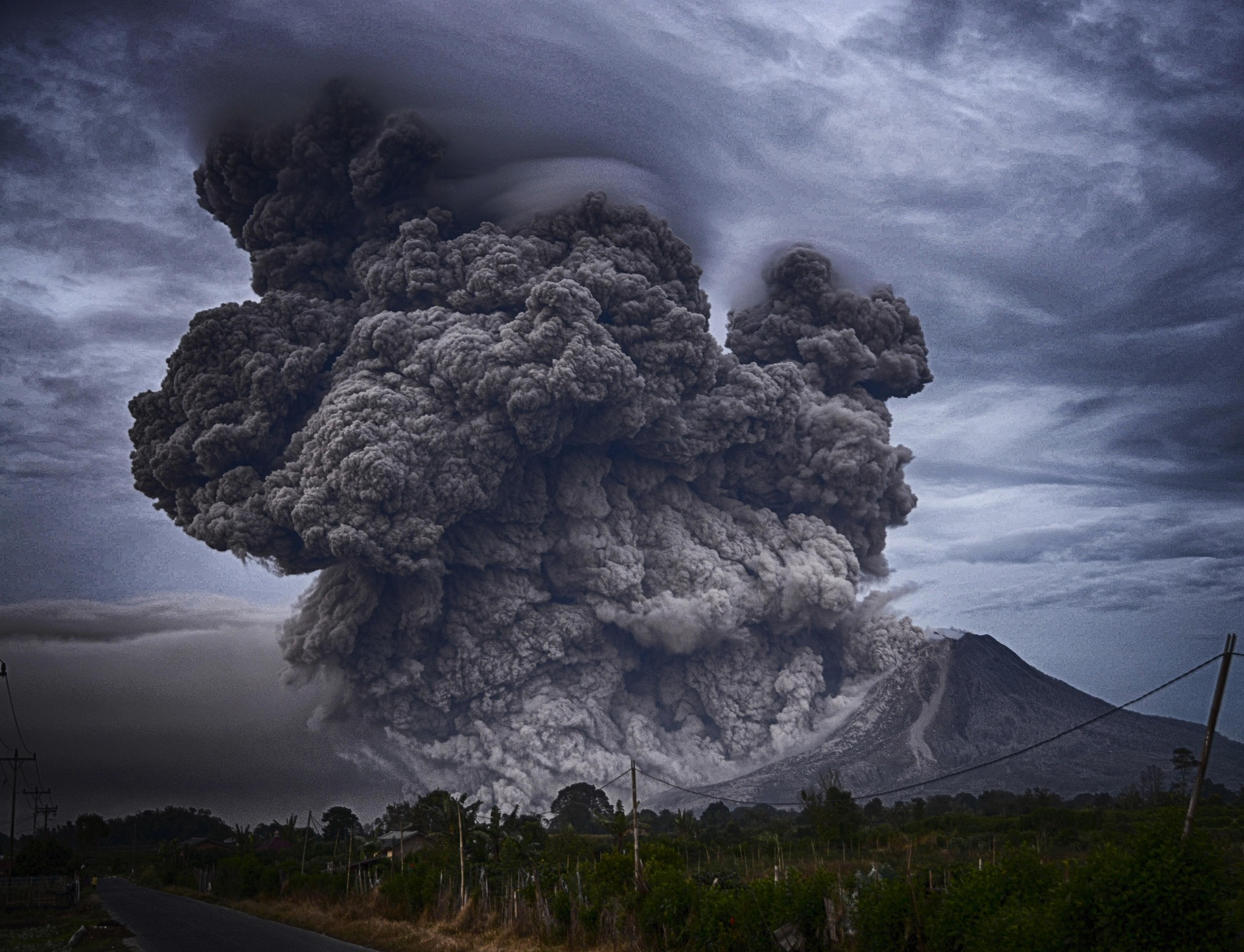
Natural Disasters
Earth's most powerful natural events — how they form, how they are measured, and how societies prepare.
Natural disasters are extreme natural events that disrupt human communities, damage infrastructure, and cause loss of life. They arise from the ordinary workings of the planet, its tectonics, atmosphere, oceans, and climate, and they are shaped as much by where people live and how societies prepare as by the physical forces involved. This page surveys the principal hazard categories, how scientists measure them, and how nations and international organizations work to reduce the risks they pose.
Overview
A natural disaster is a natural hazard that causes significant loss of life, injury, or property damage. The underlying physical event, a rupture along a fault, a tropical cyclone, a river in flood, is a natural hazard. It becomes a disaster only when it intersects with exposed and vulnerable populations, infrastructure, and economic activity. This distinction is central to modern disaster science. A large earthquake in an uninhabited region is a geophysical event; the same earthquake beneath a densely populated city with vulnerable buildings is a catastrophe.
Natural disasters are conventionally classified by origin. Geological hazards include earthquakes, volcanic eruptions, tsunamis, and landslides, and arise from the internal dynamics of the Earth. Atmospheric hazards include hurricanes, typhoons, tornadoes, and severe winter storms, and arise from weather systems in the troposphere. Hydrological hazards are dominated by floods, whether from rivers, flash runoff, or coastal storm surge. Climatological hazards include droughts, heat waves, and wildfires, which unfold over weeks, months, or years. Biological hazards, chiefly epidemics and pandemics, are treated separately in disaster statistics and are covered in greater depth on the forthcoming CountryReports page on major pandemics in history.
The principal international data source on disaster impact is the Emergency Events Database, known as EM-DAT, maintained by the Centre for Research on the Epidemiology of Disasters at the Université catholique de Louvain in Belgium. EM-DAT has recorded tens of thousands of events worldwide since 1900, and its inclusion criteria require at least ten reported deaths, one hundred people affected, a declaration of a state of emergency, or a call for international assistance. Other authoritative bodies, including the United Nations Office for Disaster Risk Reduction, the World Meteorological Organization, the United States Geological Survey, and the United States National Oceanic and Atmospheric Administration, provide specialized data on particular hazard types.
Modern disaster research emphasizes that risk is a product of hazard, exposure, and vulnerability. A community can reduce risk by addressing any of the three, by avoiding the most hazardous locations, by lowering the number of people and assets exposed, or by strengthening the resilience of buildings, infrastructure, and social systems. This framing, adopted in United Nations frameworks since the 1990s, organizes most of the preparedness and mitigation work described later in this page.
Key Facts
- Recorded events per year
- Approximately 300 to 400 in recent decades, per EM-DAT inclusion criteria
- Principal hazard categories
- Geological, atmospheric, hydrological, climatological, biological
- Average annual economic losses
- Hundreds of billions of United States dollars globally; highly variable year to year
- Annual fatalities
- Highly variable; long-term averages of tens of thousands, with individual catastrophic years reaching hundreds of thousands
- Most frequent hazard type
- Floods, which account for the largest share of recorded disaster events globally
- Deadliest modern tropical cyclone
- 1970 Bhola Cyclone in what is now Bangladesh, with estimates of approximately 300,000 to 500,000 deaths
- Deadliest modern earthquake
- 1976 Tangshan earthquake in China, with approximately 242,000 officially acknowledged deaths and independent estimates considerably higher
- Deadliest modern tsunami
- 2004 Indian Ocean tsunami, approximately 227,898 deaths across fourteen countries
- Principal global framework
- Sendai Framework for Disaster Risk Reduction 2015–2030, adopted by United Nations member states
Earthquakes
Earthquakes are the release of elastic strain energy that has accumulated along faults in the Earth's crust and uppermost mantle. The great majority occur along boundaries between tectonic plates, where plates converge, spread apart, or slide past one another. Secondary activity takes place within plate interiors along older fault zones and near active volcanoes. The United States Geological Survey operates the Advanced National Seismic System and participates in the Global Seismographic Network, providing near-real-time monitoring of global seismicity.
Earthquake size is reported today using the moment magnitude scale, abbreviated Mw, which is based on the physical moment of the fault rupture and is reliable across the full range of earthquake sizes. The older Richter scale, developed in the 1930s for southern California, saturates at larger magnitudes and is no longer used for significant events. Separately, the Modified Mercalli intensity scale describes the shaking actually felt at a given location, graded from imperceptible tremor to total destruction. The Pacific rim, known as the Ring of Fire, concentrates a large share of global seismic and volcanic activity, with notable activity also in the Alpide belt from the Mediterranean to Indonesia and along mid-ocean ridges.
Notable modern earthquakes illustrate the range of impacts. The 1976 Tangshan earthquake in China officially killed approximately 242,000 people, with independent scholarly estimates placing the true figure substantially higher. The 2004 Indian Ocean earthquake, with a magnitude of 9.1 to 9.3 Mw, ruptured more than 1,200 kilometres of the Sunda megathrust and generated the tsunami discussed below. The 2010 Haiti earthquake struck a densely populated area with limited seismic construction and caused catastrophic loss of life. The 2011 Tōhoku earthquake off northeastern Japan, at magnitude 9.1 Mw, was followed by the Tōhoku tsunami and the Fukushima Daiichi nuclear accident, with approximately 19,750 confirmed deaths. The February 2023 earthquakes in southeastern Turkey and northern Syria killed approximately 59,000 people. Modern engineering and strict seismic codes, combined with dense instrumentation by agencies such as the Japan Meteorological Agency and the Geological Survey of India, have measurably reduced casualties per equivalent-magnitude event in high-income, well-prepared regions.
Volcanoes
Volcanoes form where molten rock, known as magma, reaches the Earth's surface through vents in the crust. The principal volcanic landforms include shield volcanoes, built from low-viscosity basaltic lava and exemplified by those of Hawaii; stratovolcanoes, the steep composite cones such as Mount Fuji and Mount Rainier that produce many of the deadliest eruptions; and calderas, broad collapse craters produced by very large eruptions. The United States Geological Survey and its partners in the Global Volcanism Program catalogue active volcanoes worldwide, and Volcanic Ash Advisory Centres, coordinated internationally, issue warnings to aviation when ash enters the atmosphere.
Eruption size is reported using the Volcanic Explosivity Index, abbreviated VEI, which ranges from VEI 0 for effusive lava-only eruptions to VEI 8 for the largest known explosive events. Notable historical eruptions include the 79 CE eruption of Mount Vesuvius in Roman Italy, which buried the cities of Pompeii and Herculaneum; the 1815 eruption of Mount Tambora in Indonesia, the largest eruption in recorded history, which so cooled the global climate that 1816 is remembered as the Year Without a Summer; the 1883 eruption of Krakatoa; the 1980 eruption of Mount St. Helens in the United States; the 1991 eruption of Mount Pinatubo in the Philippines, which measurably cooled global average temperatures for two years; and the 2010 eruption of Eyjafjallajökull in Iceland, which produced a modest VEI 4 but disrupted European air travel on a massive scale.
Very large volcanic systems, sometimes called supervolcanoes, include the Yellowstone caldera in the western United States and the Toba caldera in Sumatra. Such systems produce infrequent but immense eruptions on geological timescales. For modern society, the most pressing volcanic hazards remain ash fall, pyroclastic density currents, lahars, which are volcanic mudflows, and lava flows, together with downstream threats to aviation, agriculture, and water supplies.
Tsunamis
A tsunami is a series of long-wavelength ocean waves generated when a large volume of water is abruptly displaced. Most tsunamis are caused by undersea earthquakes along subduction zones. Submarine landslides, volcanic eruptions, and, rarely, meteorite impacts can also produce them. In the open ocean, a tsunami may travel at the speed of a commercial jet aircraft while its wave height remains modest. As the wave approaches shallow coastal water it slows and its energy compresses vertically, sometimes producing run-up many metres above normal sea level. The first sign at shore is often an unusual withdrawal of the sea, followed by one or more destructive surges.
The 2004 Indian Ocean tsunami, generated by the magnitude 9.1 to 9.3 Mw Sumatra-Andaman earthquake, killed approximately 227,898 people across fourteen countries, including Indonesia, Thailand, Sri Lanka, and India. The event demonstrated the need for basin-wide warning systems beyond the Pacific and spurred the establishment of the Indian Ocean Tsunami Warning System. The 2011 Tōhoku tsunami, generated by the Tōhoku earthquake, overtopped sea walls along hundreds of kilometres of Japanese coastline and caused the majority of the event's casualties. The Pacific Tsunami Warning Center in Honolulu, operated by the United States National Oceanic and Atmospheric Administration, coordinates warnings across the Pacific basin, and regional centres perform the same function for the Indian Ocean, the Caribbean, and the Northeast Atlantic and Mediterranean.
Hurricanes, Typhoons, and Cyclones
Hurricanes, typhoons, and cyclones are the same meteorological phenomenon, a tropical cyclone, known by different regional names. Tropical cyclones that form in the North Atlantic and the eastern North Pacific are called hurricanes; those that form in the western North Pacific are called typhoons; and those that form in the South Pacific and the Indian Ocean are called cyclones. The storms organize over warm tropical oceans, typically where sea surface temperatures exceed twenty-six degrees Celsius to a depth of roughly fifty metres, and derive their energy from the latent heat released by condensing water vapour.
In the Atlantic basin the storms are categorized by the Saffir-Simpson Hurricane Wind Scale, graded from Category 1 to Category 5. Other basins use regionally specific scales and naming conventions. The United States National Hurricane Center, part of the National Oceanic and Atmospheric Administration, issues forecasts for the Atlantic and eastern Pacific. The Japan Meteorological Agency serves as the Regional Specialized Meteorological Centre for the western North Pacific, and the Indian Meteorological Department performs the same role for the North Indian Ocean, under coordination by the World Meteorological Organization.
The deadliest tropical cyclone in the modern historical record is the 1970 Bhola Cyclone, which struck what was then East Pakistan and is now Bangladesh. Reported death tolls range from approximately 300,000 to 500,000; the precise figure is not known, and the range reflects the difficulty of counting casualties across a vast inundated delta. Other notable events include Hurricane Katrina, which struck the United States Gulf Coast in 2005 and caused catastrophic flooding in New Orleans; Typhoon Haiyan, which devastated the central Philippines in 2013; the Atlantic hurricane season of 2017, which produced Hurricanes Harvey, Irma, and Maria; and Cyclone Mocha, which struck the coast of Myanmar in 2023.
Tornadoes
A tornado is a rotating column of air in contact with both a cumulonimbus cloud base and the ground. Most form from the mesocyclones of supercell thunderstorms, in which rotating updrafts draw air upward at high speed. In the United States, tornado intensity is rated on the Enhanced Fujita scale, introduced in 2007 to replace the original Fujita scale, and graded from EF0 to EF5 based on observed damage. The United States Storm Prediction Center, located in Norman, Oklahoma, issues tornado watches and coordinates with local National Weather Service offices that issue tornado warnings, often within minutes of detection on Doppler radar.
The central United States, an area informally known as Tornado Alley, experiences the most frequent and intense tornadoes in the world because of a recurring collision of cool dry air from the Rocky Mountains, warm moist air from the Gulf of Mexico, and fast-moving air aloft. The Joplin, Missouri tornado of May 2011 was an EF5 that killed 158 people. The Moore, Oklahoma tornado of May 2013 was also rated EF5. The April 2011 Super Outbreak produced more than three hundred confirmed tornadoes across the southeastern United States over three days, and the April 1974 Super Outbreak set a long-standing benchmark for a single continental outbreak. Tornadoes are uncommon but not unknown elsewhere in the world; documented outbreaks have occurred in Europe, in the Ganges delta region of India and Bangladesh, and on the pampas of Argentina.
Floods
Floods are the most frequent natural disaster worldwide by event count. They take several forms. River floods occur when rainfall or snowmelt exceeds channel capacity over hours or days. Flash floods occur within minutes to a few hours in response to intense local rainfall, dam failure, or ice-jam release. Coastal floods are produced by storm surge during tropical cyclones and extratropical storms, sometimes compounded by high tides. Urban floods, increasingly common as cities expand over impermeable surfaces, occur when local drainage systems are overwhelmed. The United States National Oceanic and Atmospheric Administration, the World Meteorological Organization, and national hydrological services coordinate forecasting globally.
Historical flood disasters include the 1887 Yellow River flood in Qing dynasty China, and the 1931 Central China floods along the Yangtze and Huai river basins, whose death-toll estimates range from approximately one to four million. Those 1931 figures, originating largely from contemporary Chinese government and relief reports, are widely regarded by modern historians as imprecise and likely inflated, but the event is nonetheless among the deadliest natural disasters in recorded history. The 1970 Bhola Cyclone storm surge across what is now Bangladesh is counted among both tropical-cyclone and flood disasters.
Modern flood losses are rising in many regions. The Intergovernmental Panel on Climate Change has concluded that heavy precipitation events have become more frequent and more intense across much of the world since the mid-twentieth century. Engineering responses to flood risk include levees and flood walls along major rivers, dams for upstream storage and flow regulation, and coastal defences. The Netherlands Delta Works, constructed following the catastrophic North Sea flood of 1953, combine dams, storm surge barriers, and sluices to protect the low-lying southwestern Netherlands from the sea, and are widely studied as a model integrated coastal defence.
Wildfires
Wildfires are uncontrolled fires that burn in vegetation, including forests, shrublands, grasslands, and peatlands. They are a natural component of many ecosystems, and fire-adapted species depend on periodic burning for regeneration. In recent decades, however, the frequency, extent, and intensity of wildfires have increased in many regions, driven by rising temperatures, earlier snowmelt, longer dry seasons, a buildup of fuel from past fire suppression, and expansion of human settlement into the wildland-urban interface. The National Interagency Fire Center in the United States coordinates federal wildfire response, and the European Forest Fire Information System coordinates monitoring and reporting across the European Union.
Recent notable fire seasons include the Australian Black Summer of 2019 to 2020, which burned more than 18 million hectares across southeastern Australia; the 2018 Camp Fire in California, the deadliest wildfire in the modern history of the United States; the 2023 Maui fires in Hawaii, which destroyed much of the town of Lahaina; the peat fires that recur in Indonesia and send transboundary smoke across Southeast Asia; and the Canadian wildfire season of 2023, whose smoke travelled across the continent and degraded air quality along the eastern seaboard of the United States for weeks. Contemporary management combines suppression of high-threat fires with prescribed burning to reduce fuel loads, and renewed attention to Indigenous fire stewardship practices that shaped many landscapes before industrial-era suppression.
Droughts and Famines
Drought is a prolonged deficit in precipitation relative to long-term averages, and it is classified by the World Meteorological Organization into meteorological, agricultural, hydrological, and socioeconomic categories according to what it depletes: rainfall, soil moisture, surface and groundwater, or human welfare. Drought is often the slowest of natural disasters to arrive, unfolding over seasons or years, and the most difficult to declare ended.
Notable droughts include the United States Dust Bowl of the 1930s, which combined severe drought with poor soil management across the Great Plains; the Ethiopian famine of 1983 to 1985, which killed hundreds of thousands; persistent droughts across the African Sahel in the late twentieth and early twenty-first centuries; and the drought of 2020 to 2022 in the Horn of Africa, which placed millions in Ethiopia, Somalia, and Kenya at risk of famine. Famine itself is rarely caused by drought alone. The economist Amartya Sen, in his study of twentieth-century famines, emphasized that entitlement collapse, the loss of a population's ability to command food through purchase, trade, or labour, frequently interacts with drought, armed conflict, and policy failure to produce mass starvation. The Intergovernmental Panel on Climate Change projects that under continued warming, some regions will experience longer and more severe drought cycles, with significant implications for agriculture and water supply.
Landslides and Avalanches
Landslides are the downslope movement of rock, soil, and debris under gravity. They are often triggered by earthquakes, by prolonged or intense rainfall saturating hillslope soils, by volcanic activity, or by human modifications such as undercutting of slopes, deforestation, and construction on unstable ground. Avalanches, the analogous phenomenon in snow, are most common on steep mountain slopes and can be triggered by fresh snowfall, wind loading, rapid warming, or the passage of skiers and climbers. The United States Geological Survey maintains the Landslide Hazards Program and produces national susceptibility mapping.
The 1970 Ancash earthquake in Peru dislodged a massive ice-and-rock avalanche from the north face of Nevado Huascarán that buried the town of Yungay and killed an estimated 20,000 people, one of the deadliest single landslide events in recorded history. Monsoonal rainfall regularly triggers deadly landslides in the Himalayan region, in the Philippines, and in Central America. In mountain regions with organized recreation, national avalanche centres issue daily hazard forecasts, and modern backcountry users carry avalanche transceivers and other rescue equipment as a matter of course.
Disaster Risk Reduction and Response
Modern disaster policy is organized internationally through the Sendai Framework for Disaster Risk Reduction, adopted by United Nations member states in 2015 and running through 2030. The framework identifies four priorities: understanding disaster risk, strengthening governance to manage it, investing in resilience, and enhancing preparedness for effective response and for Build Back Better recovery. It succeeds the earlier Hyogo Framework and is coordinated by the United Nations Office for Disaster Risk Reduction. National governments report periodically against common indicators, including disaster mortality, economic loss, and critical infrastructure damage.
Operational response is carried out by national civil-protection and emergency-management agencies, the armed forces when tasked, and a large network of non-governmental organizations. The International Federation of Red Cross and Red Crescent Societies coordinates across its 191 national societies for immediate relief, shelter, health, and long-term recovery. United Nations agencies, including the World Food Programme and the Office for the Coordination of Humanitarian Affairs, lead international humanitarian response. Early-warning systems, increasingly interoperable across borders, are a core area of investment and have demonstrably reduced mortality from tropical cyclones and tsunamis where they have been deployed. The insurance and reinsurance industries, concentrated in financial centres such as London, Zurich, and Munich, absorb a significant share of global disaster losses and provide quantitative risk modelling that informs public-sector planning.
Effective risk reduction also depends on local and community-level action. Building codes, zoning restrictions in flood plains and tsunami inundation zones, community evacuation drills, and the incorporation of Indigenous and local knowledge about historical hazards all contribute to resilience. The Build Back Better principle, formalized in the Sendai Framework, holds that recovery and reconstruction after a disaster should not merely restore pre-disaster conditions but should reduce future vulnerability. Climate adaptation, which addresses longer-term shifts in hazard patterns, is increasingly integrated with traditional disaster risk reduction rather than treated as a parallel discipline.
Sources
Detailed citations, data references, and institutional sources for all CountryReports content are listed on the Sources page. The following government agencies, intergovernmental bodies, and research institutions are the primary authorities we rely on for natural-disaster content. Each link points to the institution's homepage.
United States Government Agencies
- United States Geological Survey (USGS) — earthquakes, volcanoes, tsunamis, and landslides, including the Advanced National Seismic System and the Global Seismographic Network.
- National Oceanic and Atmospheric Administration (NOAA) — hurricanes, tropical storms, floods, severe weather, and climate data.
- National Hurricane Center (NHC) — forecasts and advisories for Atlantic and eastern Pacific tropical cyclones.
- Storm Prediction Center (SPC) — severe-thunderstorm and tornado forecasting for the contiguous United States.
- Pacific Tsunami Warning Center — basin-wide tsunami warnings for the Pacific and affiliated ocean regions.
- Federal Emergency Management Agency (FEMA) — United States domestic preparedness, response, recovery, and historical archive.
- National Interagency Fire Center (NIFC) — coordination of federal wildland fire response in the United States.
International and Intergovernmental Bodies
- United Nations Office for Disaster Risk Reduction (UNDRR) — coordinating body for the Sendai Framework for Disaster Risk Reduction 2015–2030.
- World Meteorological Organization (WMO) — international coordination of weather, climate, and hydrological services.
- International Federation of Red Cross and Red Crescent Societies (IFRC) — global network of 191 national societies providing relief, recovery, and community preparedness.
National Meteorological and Geological Services
- Japan Meteorological Agency (JMA) — Regional Specialized Meteorological Centre for the western North Pacific; earthquakes, volcanoes, and tsunamis in Japan.
- Indian Meteorological Department (IMD) — Regional Specialized Meteorological Centre for the North Indian Ocean; cyclones and severe weather in South Asia.
- Geological Survey of India — seismic monitoring, landslide hazard mapping, and earth-science data for India.
- European Forest Fire Information System (EFFIS) — operated by the Joint Research Centre of the European Commission; wildfire monitoring and reporting across Europe.
Academic Research Centres
- Centre for Research on the Epidemiology of Disasters (CRED) — at the Université catholique de Louvain in Belgium; maintains the Emergency Events Database (EM-DAT), the principal international dataset on disaster impact.
If you notice an error or would like to suggest a correction, please use our contact page to get in touch.