
 English
 Español
 中文
中文 हिन्दी
 Français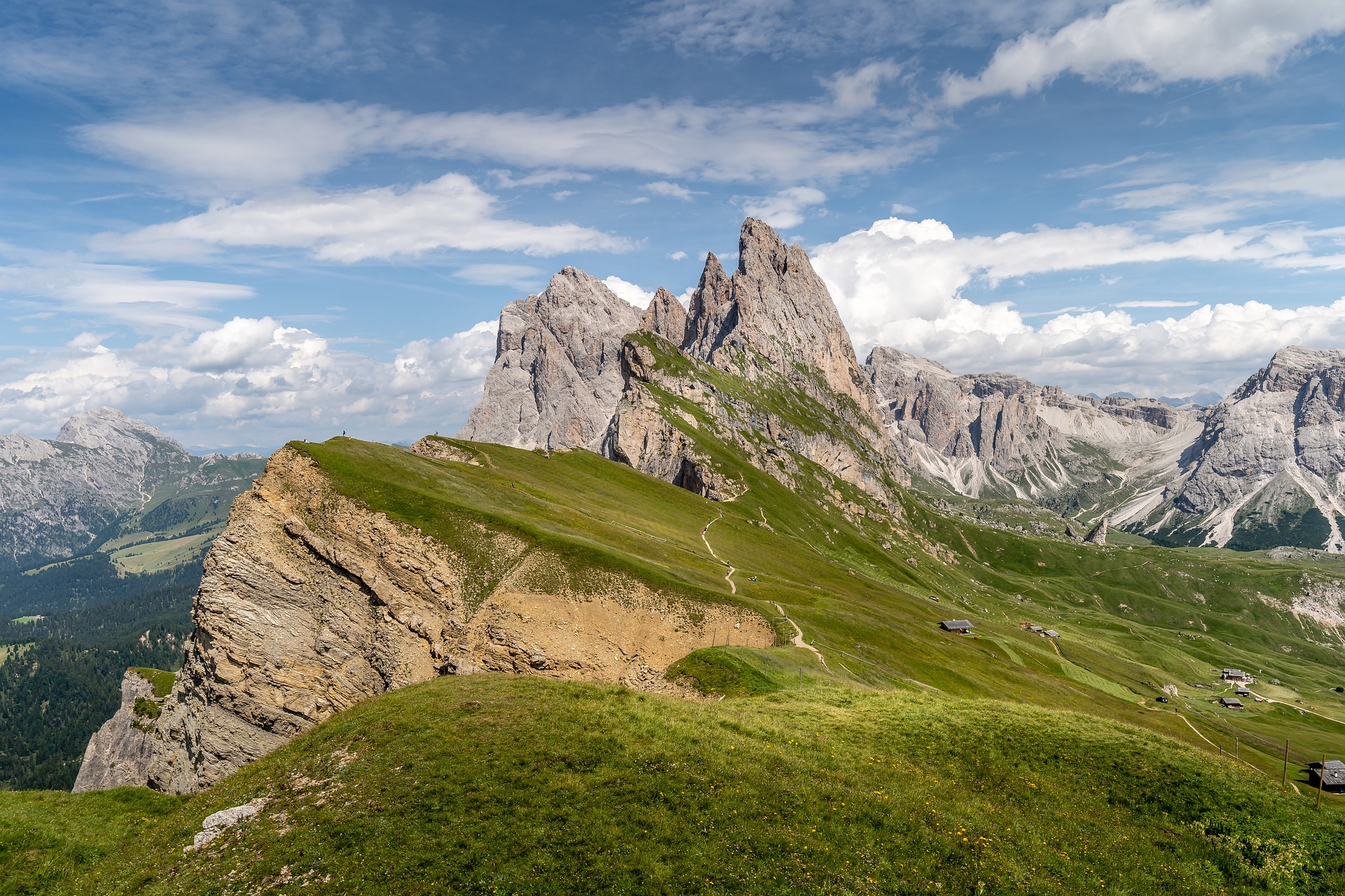
Mountain Ranges of the World
The geological spines of continents — how they form, why they matter, and the life they support.
Mountain ranges are among the most prominent features of the solid Earth, rising as continuous belts of elevated terrain that record hundreds of millions of years of geological history. They cover roughly one quarter of the planet's land surface, provide the headwaters of the world's major rivers, shelter distinctive ecosystems and cultures, and continue to shape climate, trade, and settlement patterns in ways that are often invisible from the lowlands below.
Overview
A mountain is most commonly defined as a landform that rises prominently above its surroundings, typically with steep slopes, a confined summit area, and considerable local relief. Geographers disagree on an exact elevation threshold, because local relief matters as much as absolute height. A landform two thousand metres above sea level is unremarkable on the Tibetan Plateau yet forms a dominant peak in coastal Norway. For this reason, most classifications used by the United Nations Environment Programme and the Food and Agriculture Organization combine elevation, slope, and local relief to identify mountain terrain.
By these combined measures, mountains cover approximately twenty five percent of the Earth's land surface. They are unevenly distributed. Asia holds the highest and most extensive mountain systems, while Australia has the smallest proportion of its land surface classified as mountainous. Mountain regions are home to an estimated fifteen percent of the global human population, a figure that rises above one third when neighbouring foothills and highland valleys are included. Although mountain communities are a minority of humanity, their livelihoods, cultures, and traditional knowledge systems are deeply tied to environments that are often harsher, more isolated, and more economically marginal than lowland regions.
Mountains also supply freshwater to a disproportionate share of humanity. Snowpack, glaciers, and high precipitation feed the headwaters of almost every major river system, and lowland populations draw between roughly sixty and eighty percent of their freshwater from mountain catchments. For this reason the United Nations describes mountains as the water towers of the world. Rice, wheat, and cotton agriculture in Pakistan, India, Bangladesh, northern China, Iran, Iraq, Egypt, and many other countries depend on flow generated in high terrain, and hydroelectric power produced from mountain rivers supplies a large share of national electricity across South America, central Europe, and the Himalayan region.
The pages that follow survey how mountains form, examine the great ranges by continent, describe the ecosystems and cultures of high country, review the history of mountaineering, and consider the pressures that now threaten mountain environments. They conclude with a summary of the international frameworks established to protect them and a list of the government agencies and research institutions used as sources for this content.
Key Facts
- Highest peak on Earth
- Mount Everest — 8,848.86 m (Himalayas, Nepal and China border)
- Second highest
- K2 — 8,611 m (Karakoram, Pakistan and China border)
- Third highest
- Kangchenjunga — 8,586 m (Himalayas, Nepal and India border)
- Highest outside Asia
- Aconcagua — 6,961 m (Andes, Argentina)
- Highest in North America
- Denali — 6,190 m (Alaska Range, United States)
- Highest in Africa
- Kilimanjaro — 5,895 m (Tanzania; volcanic, not part of a range)
- Highest in Western Europe
- Mont Blanc — 4,808 m (Alps, France and Italy border)
- Longest continental range
- The Andes — approximately 7,000 km from Venezuela to Tierra del Fuego
- Share of global land surface
- Approximately 25 percent classified as mountainous
- Share of global population
- Approximately 15 percent live in mountain regions
- Freshwater supplied
- Approximately 60 to 80 percent of global freshwater originates in mountain catchments
The concept of the Seven Summits, introduced by the American climber Richard Bass in the 1980s, identifies the highest mountain on each of the seven continents. It is the most widely used benchmark in high-altitude mountaineering. The conventional list includes Everest, Aconcagua, Denali, Kilimanjaro, Mount Elbrus in the Caucasus, Vinson Massif in the Transantarctic Mountains, and either Puncak Jaya in Indonesia or Mount Kosciuszko in Australia, depending on whether Oceania or continental Australia is chosen.
How Mountains Form
Mountains form through the interaction of two opposing processes. Tectonic uplift raises rock from the interior of the Earth; erosion, driven by rivers, glaciers, wind, and gravity, wears it down. The balance between these forces determines how tall a range becomes and how long it survives. The United States Geological Survey and NASA Earth Observatory describe the modern framework for understanding these processes, known as plate tectonics, which treats the outer shell of the Earth as a set of rigid plates that slide, collide, and separate over geological time.
Most of the world's great mountain ranges have formed at convergent plate boundaries, where one plate moves toward another. When two continental plates collide, neither is dense enough to sink beneath the other. The crust thickens, buckles, and folds upward. The Himalayas are the textbook example, created by the ongoing collision of the Indian plate with the Eurasian plate that began approximately fifty million years ago and continues today. The European Alps formed in a similar way through the collision of the African plate with Eurasia, and many European sub-ranges, including the Pyrenees and Carpathians, are products of the same broad event.
Where an oceanic plate converges with a continental plate, the denser oceanic plate descends, or subducts, beneath the continent. Fluids released from the subducting slab trigger melting in the mantle above, and the resulting magma rises to build long volcanic arcs along the continental margin. The Andes of western South America are the archetypal cordillera of this type, formed as the Nazca plate subducts beneath the South American plate. The Cascade Range of the northwestern United States, the Aleutian arc of Alaska, and the mountainous spine of the Japanese archipelago share the same origin.
Fault-block mountains form where the crust is stretched rather than compressed. Large blocks of rock are lifted along near-vertical faults while adjacent blocks drop down, producing sharp scarps and long basins. The Sierra Nevada of California and the Teton Range of Wyoming are classic North American examples, as are the numerous ranges of the Basin and Range Province. Residual or erosional mountains are the worn-down roots of older ranges. The Appalachians of eastern North America were once as tall as the modern Himalayas but have been reduced over hundreds of millions of years to rounded, forested ridges. Volcanic mountains, including the Hawaiian-Emperor chain, Mount Kilimanjaro, and the stratovolcanoes of the Cascades, are built directly by eruption of lava and ash. The Hawaiian chain in particular is the product of a mantle plume, a column of hot rock rising from deep within the Earth, rather than a plate boundary.
Once uplifted, mountains are shaped by erosion. Rivers carve V-shaped valleys into their flanks. Glaciers, during ice ages and in present-day high ranges, carve U-shaped valleys, knife-edged ridges known as arêtes, and cirques at their heads. Freeze-thaw weathering fragments exposed rock into the talus slopes seen at the base of so many peaks. Over geological timescales, erosion can remove kilometres of material and expose the deep crystalline cores of ancient mountain belts, as can be seen today in the rocks of the Scottish Highlands, the Scandinavian Mountains, and the Canadian Shield.
The Himalayas
The Himalayas are the highest and youngest of the great mountain systems. Born of the collision between the Indian and Eurasian plates some forty to fifty million years ago, the range includes all fourteen peaks on Earth that rise above eight thousand metres, including Mount Everest, K2 in the adjacent Karakoram, Kangchenjunga, Lhotse, Makalu, Cho Oyu, Dhaulagiri, Manaslu, and Annapurna. The range forms a great arc across five countries. It stretches from northern Pakistan through India, Nepal, and Bhutan into western China, bordering the high Tibetan Plateau to the north.
The collision that raised the Himalayas has not ended. Measurements by satellite geodesy reported by the United States Geological Survey show that the Indian plate continues to push northward at roughly four to five centimetres each year, driving ongoing uplift and frequent earthquakes across the Himalayan arc. Major historical quakes in Bihar in 1934, Assam in 1950, Kashmir in 2005, and Nepal in 2015 all reflect the living tectonics of the range.
The Himalayas exert a decisive control on South Asian climate. They block the cold continental winds of Inner Asia from reaching the Indian subcontinent and force the moisture-laden winds of the summer monsoon to rise, cool, and release their water as rain and snow on the southern slopes. The resulting discharge feeds the Indus, the Ganges, and the Brahmaputra, three of the most important river systems in the world. The International Centre for Integrated Mountain Development, headquartered in Kathmandu, coordinates research on these water systems across the Hindu Kush Himalaya region and has repeatedly warned that rapid warming is reducing the reliability of snow and glacier contributions to downstream flow.
For human cultures, the Himalayas are sacred ground. Mount Kailash in western Tibet is revered in Hinduism, Buddhism, Jainism, and the indigenous Bön tradition. The Ganges, which descends from the range at the glacier of Gaumukh, is among the most sacred rivers in Hinduism. Tibetan Buddhism, the Sherpa culture of the Khumbu region of Nepal, and a constellation of smaller mountain communities all express a long relationship with high places. The first confirmed ascent of Mount Everest, by Edmund Hillary of New Zealand and Tenzing Norgay of Nepal on 29 May 1953, remains the most celebrated single climb in mountaineering history.
The Andes
The Andes form the longest continental mountain range on Earth, running for roughly seven thousand kilometres along the entire western coast of South America. They traverse Venezuela, Colombia, Ecuador, Peru, Bolivia, Argentina, and Chile, terminating in the cliffs and fjords of Tierra del Fuego. Aconcagua, on the border between Argentina and Chile, rises to 6,961 metres and is the highest peak in the Western and Southern Hemispheres.
The Andes are a classic volcanic arc built by the subduction of the Nazca plate beneath the South American plate. Active stratovolcanoes, among them Cotopaxi in Ecuador, Sabancaya in Peru, and Villarrica in Chile, punctuate the range. The Smithsonian Global Volcanism Program maintains continuous monitoring data on these volcanoes. Frequent and occasionally devastating earthquakes reflect the same tectonic setting; the magnitude 9.5 Valdivia earthquake of 1960, the largest instrumentally recorded earthquake in history, was a product of this subduction zone.
The Andes are the cradle of a succession of great civilizations. The Chavín, Moche, Wari, Tiwanaku, Nazca, and Chimú peoples built complex urban societies in Andean valleys and on the coastal margin long before the rise of the Inca empire, which at its height in the early sixteenth century stretched from southern Colombia to central Chile and governed perhaps twelve million people from its capital at Cusco. The terraced fields, irrigation canals, road systems, and stone architecture of Machu Picchu, Ollantaytambo, and Choquequirao remain among the most remarkable engineering achievements of the pre-industrial world.
Modern Andean countries remain deeply shaped by the range. The Altiplano, a high plateau shared by Peru, Bolivia, and Chile, is one of the most extensive high plateaus outside Tibet and hosts Lake Titicaca, the highest large navigable lake in the world at 3,812 metres. Andean mining supplies a large share of global copper, silver, lithium, and other metals, and Andean agriculture produced the potato, tomato, maize, and quinoa that transformed food systems on every other continent after 1500.
The Rocky Mountains
The Rocky Mountains are the principal cordillera of North America. They extend for roughly 4,800 kilometres from northern British Columbia in Canada southward through the western United States to New Mexico, where they merge with the highlands of the Mexican Plateau. The range comprises many named sub-ranges, including the Canadian Rockies, the Wind River Range, the Front Range, the Sawatch Range, the Sangre de Cristo Mountains, and the San Juan Mountains, with dozens of peaks above four thousand metres in Colorado alone.
The Rockies are older than the Himalayas or the Alps. Most of the uplift occurred during the Laramide orogeny, an episode of mountain building between roughly eighty and forty million years ago that was driven by unusually shallow subduction of the oceanic plate off western North America. Subsequent erosion, glaciation during Pleistocene ice ages, and renewed volcanism have sculpted the range into its modern form. The Continental Divide of the Americas runs along the crest of the Rockies, separating rivers that drain to the Pacific from those that flow to the Atlantic and Arctic oceans.
The Rockies are home to some of the most celebrated protected areas in North America. Yellowstone National Park, established in 1872, was the first national park anywhere in the world and sits atop a restless volcanic hotspot. Glacier National Park in Montana and Waterton Lakes National Park in Alberta together form a designated International Peace Park. Rocky Mountain National Park in Colorado preserves alpine tundra, sub-alpine forest, and habitat for elk, bighorn sheep, and black bear. Banff, Jasper, Yoho, and Kootenay national parks protect the Canadian flank.
Human use of the Rockies spans millennia. Indigenous peoples including the Shoshone, Ute, Blackfoot, Crow, Nez Perce, and many others hunted, traded, and made seasonal homes in the range long before European contact. In the nineteenth century the mountains were crossed by fur traders, the Lewis and Clark expedition, the wagon trains of the Oregon and Mormon trails, and the transcontinental railroads. Mining for gold, silver, copper, lead, and zinc shaped generations of boom-and-bust towns. Today the Rocky Mountain region is a major source of natural gas and coal, a globally significant centre of ski tourism, and home to growing metropolitan areas along the Front Range in Colorado.
The Alps
The Alps arc across south-central Europe, crossing eight countries: France, Monaco, Italy, Switzerland, Liechtenstein, Austria, Germany, and Slovenia. Although modest in global terms, with the highest point, Mont Blanc, rising to 4,808 metres, the range has exercised an outsized influence on European history, science, and culture.
Like the Himalayas, the Alps are the product of continental collision. Beginning roughly one hundred million years ago the African plate began to move northward against Eurasia, squeezing and folding the sediments of an ancient ocean known as the Tethys. The resulting nappes, great sheets of rock transported tens of kilometres by tectonic forces, are a defining feature of Alpine geology and are studied by geologists from around the world as the model example of compressional mountain building. Earthquake activity in the range is moderate compared with the Himalayas or Andes, but still significant, and the range continues to rise slowly even as erosion keeps pace.
The Alps are heavily glaciated. The Aletsch Glacier in Switzerland remains the largest glacier in the range, although, like nearly all Alpine glaciers, it has been losing mass for more than a century. Alpine ice supplies the headwaters of the Rhine, the Rhône, the Po, the Danube, and the Adige, four of which rank among Europe's most important rivers. The ski industry, hydroelectric power, summer tourism, and intensive dairy agriculture all depend on the region's abundant mountain precipitation.
The Alps are also the birthplace of modern mountaineering. The first ascent of Mont Blanc in 1786 by Jacques Balmat and Michel-Gabriel Paccard, undertaken at the urging of the naturalist Horace-Bénédict de Saussure, is conventionally cited as the beginning of the sport. The golden age of Alpinism followed in the middle of the nineteenth century, culminating in the dramatic first ascent of the Matterhorn by Edward Whymper's party in 1865. Today the Alpine tourism economy generates tens of billions of euros each year and supports hundreds of mountain communities.
Other Major Ranges
Beyond the four best-known systems, dozens of other mountain ranges shape the geography, climate, and culture of their regions. The selection below is not exhaustive; the full list of named ranges and sub-ranges is far longer.
The Urals
A long, low range running north-south for about 2,500 kilometres through western Russia, conventionally marking the boundary between Europe and Asia. Heavily eroded and mineral-rich.
The Caucasus
Lies between the Black Sea and the Caspian Sea and traverses Russia, Georgia, Armenia, and Azerbaijan. Mount Elbrus, at 5,642 metres, is the highest peak and is usually counted among the Seven Summits as the highest in Europe.
The Atlas Mountains
Extend approximately 2,500 kilometres across Morocco, Algeria, and Tunisia. They separate the Mediterranean and Atlantic coasts from the Sahara and include Toubkal, at 4,167 metres the highest peak in North Africa.
The Ethiopian Highlands
A plateau and mountain region in the Horn of Africa, sometimes called the roof of Africa, with extensive territory above three thousand metres. The source region of the Blue Nile, which supplies most of the flow of the main Nile.
The Drakensberg
The highest range in Southern Africa, extending along the eastern escarpment of South Africa and Lesotho. Thabana Ntlenyana, at 3,482 metres, is the highest point on the African mainland south of Kilimanjaro.
The Appalachians
Run for roughly 2,400 kilometres from Newfoundland through the eastern United States to Alabama. Among the oldest mountain systems on Earth, worn down from a former Himalayan scale to rounded, forested ridges.
The Sierra Madre
A collective term for three principal ranges in Mexico — Occidental, Oriental, and del Sur — together forming a broad mountainous spine that dominates the Mexican interior.
The Pyrenees
Form the natural border between Spain and France, extending approximately 430 kilometres from the Bay of Biscay to the Mediterranean. Aneto, at 3,404 metres, is the highest peak.
The Carpathians
Arc across Eastern Europe through the Czech Republic, Slovakia, Poland, Hungary, Ukraine, and Romania. Host some of Europe's last extensive old-growth forests and significant populations of brown bear, wolf, and lynx.
The Scandinavian Mountains
Run along the border between Norway and Sweden. Heavily glaciated during the last ice age, the range produced the fjords that indent the Norwegian coast and remains home to the largest ice caps in mainland Europe.
The Japanese Alps
A name applied to three linked ranges on the central island of Honshu in Japan. Tectonically active, they rise above three thousand metres and mark the convergence of four plates.
The Zagros Mountains
Extend for roughly 1,600 kilometres through western Iran from the Turkish border to the Strait of Hormuz, with heights above four thousand metres. The most prolific oil province in the world lies beneath the Zagros foothills.
The Hindu Kush
Extends across central Afghanistan and into northern Pakistan. Tirich Mir, at 7,708 metres, is the highest peak. The range has been a crossroads of empires from the time of Alexander the Great to the modern era.
The Pamir, Tian Shan, Kunlun, and Altai
A cluster of enormous ranges radiating across Central Asia. The Pamir is sometimes called the Roof of the World; the Tian Shan stretches through Kyrgyzstan, Kazakhstan, and western China; the Kunlun forms the northern rampart of the Tibetan Plateau; and the Altai reach into Siberia and Mongolia.
The Great Dividing Range
Extends more than 3,500 kilometres along the eastern seaboard of Australia. Mount Kosciuszko, at 2,228 metres, is the highest peak on the Australian mainland.
The Southern Alps of New Zealand
Run the length of the South Island of New Zealand, rising sharply from the Tasman Sea. Aoraki / Mount Cook is the highest peak at 3,724 metres. The range is heavily glaciated and tectonically very young.
The Transantarctic Mountains
Divide East and West Antarctica for approximately 3,500 kilometres. Vinson Massif, in the Ellsworth Range of West Antarctica, is the highest peak on the continent at 4,892 metres and one of the Seven Summits.
Mountain Ecosystems
Mountains are among the richest ecosystems on Earth. As one climbs a mountain the temperature falls, precipitation patterns change, and vegetation communities shift within short vertical distances. The result is a series of stacked life zones that replicate, in miniature, the biological transition from tropical lowlands to polar regions. This altitudinal zonation was first described systematically by the German naturalist Alexander von Humboldt in his studies of the tropical Andes at the beginning of the nineteenth century and has shaped mountain ecology ever since.
A typical sequence in a mid-latitude mountain begins with montane forest on the lower slopes, dominated by broadleaf or conifer species depending on latitude. Above the montane zone lies sub-alpine forest, where trees become smaller and more widely spaced and species composition is limited to a few cold-tolerant conifers. The timberline marks the upper limit of closed forest. Above it lies the alpine zone, where small herbs, grasses, cushion plants, and lichens persist in a short growing season. Still higher, in the nival zone, vegetation is absent and the landscape is dominated by rock, snow, and ice.
Mountain ranges disproportionately harbour biodiversity. The Global Mountain Biodiversity Assessment, an international research initiative, reports that mountain regions contain roughly half of the world's designated biodiversity hotspots, defined as areas exceptionally rich in endemic species and under exceptional threat. The tropical Andes and the Eastern Himalayas are consistently ranked among the most species-rich terrestrial environments on the planet. Cloud forests, which occur in a narrow altitudinal band where orographic lift produces near-continuous fog, are particularly noted for their diversity of epiphytes, amphibians, and birds.
Mountains also produce high levels of endemism. Populations separated by deep valleys, steep ridges, or contrasting climates evolve in relative isolation, often giving rise to species found nowhere else. The tepuis of the Guiana Highlands, the sky islands of the southwestern United States and northern Mexico, the Afromontane forests of eastern Africa, and the highlands of Papua New Guinea are all celebrated cases of mountain endemism. Iconic mountain animals include the snow leopard of Central Asia, the Andean condor, the Alpine ibex, the North American bighorn sheep, the Ethiopian gelada, and the Himalayan red panda.
Mountain People and Cultures
Mountain communities exist on every inhabited continent and share a set of common features. They typically live at higher elevations than their lowland neighbours, farm on steep or terraced land, depend on livestock as much as on crops, and have historically been more isolated from central state authority. At the same time each mountain culture carries distinctive languages, technologies, and belief systems rooted in its own range.
In the Himalayas the Sherpa people of the Khumbu region of Nepal are the best known of many mountain communities. Originally migrants from eastern Tibet who settled in the Nepalese highlands in the sixteenth century, Sherpas have long combined yak herding, buckwheat and potato agriculture, and trans-Himalayan trade. Since the mid twentieth century they have also become indispensable to expedition mountaineering, and the term sherpa is now used more broadly in climbing contexts. Tibetans on the high plateau above the range cultivate barley, raise yaks and sheep, and practice a distinctive form of Mahayana Buddhism. Smaller mountain communities across Nepal, Bhutan, the Indian states of Himachal Pradesh, Uttarakhand, Sikkim, and Arunachal Pradesh, and the Pakistani districts of Hunza and Baltistan add further linguistic and cultural diversity to the range.
The Andes are home to the Quechua and Aymara peoples, whose languages are spoken by roughly eight and two million people respectively and who preserve agricultural, weaving, and ritual traditions with roots in the Wari, Tiwanaku, and Inca civilizations. Andean farmers developed more than three thousand named varieties of potato, along with a wide range of cold-adapted grains and tubers, and continue to manage the freeze-dried potato product known as chuño. The high Altiplano communities of Bolivia, Peru, and northern Chile have lived above four thousand metres for thousands of years and show marked physiological adaptation to low oxygen. In North America, Indigenous peoples of the Rocky Mountains and the Pacific Cordillera, including the Shoshone, Ute, Blackfoot, Secwépemc, and Nlaka'pamux, maintain active connections with mountain landscapes as sources of food, ceremony, and identity.
Elsewhere in the world, mountain people include the Basques of the western Pyrenees, the Swiss and Austrian Alpine communities, the Druze of the Levantine uplands, the Kurdish peoples of the Zagros and eastern Anatolian highlands, the Berber communities of the Atlas, the Amhara and Oromo of the Ethiopian Highlands, and the many Papuan peoples of the New Guinea Highlands, who were among the last human populations to come into sustained contact with the wider world. Research on high-altitude adaptation compiled by the Mountain Research Initiative describes genetic and physiological differences between Andean, Himalayan-Tibetan, and Ethiopian populations that represent three distinct evolutionary solutions to life at low oxygen pressure.
Mountaineering History
The deliberate ascent of mountains for exploration, science, or recreation is a relatively modern phenomenon. Although shepherds, hunters, and traders crossed high passes for millennia, the first ascent considered the beginning of modern mountaineering is the climb of Mont Blanc on 8 August 1786 by the chamois hunter Jacques Balmat and the physician Michel-Gabriel Paccard. The naturalist Horace-Bénédict de Saussure, who had offered a reward for the first ascent and made the second himself in 1787, is often credited as the intellectual founder of the sport.
The nineteenth century was dominated by exploration of the Alps. British climbers in particular, organised from 1857 under the Alpine Club in London, made first ascents of most of the major Alpine peaks over a single remarkable generation. The golden age of Alpinism is conventionally said to have culminated on 14 July 1865, when Edward Whymper's party reached the summit of the Matterhorn. The tragedy that followed on the descent, in which four of the seven climbers died, shaped public attitudes to the sport for decades.
Attention turned next to higher ranges. The Caucasus, the Pamirs, the Andes, and above all the Himalayas and Karakoram attracted expeditions from Britain, Germany, Italy, the United States, Japan, and other nations. The first attempts on Mount Everest in the 1920s established a tradition of expedition mountaineering that culminated in the successful British expedition of 1953, which placed Edmund Hillary and Tenzing Norgay on the summit on 29 May. K2 was first climbed the following year, in 1954, by an Italian expedition led by Ardito Desio, with Achille Compagnoni and Lino Lacedelli reaching the summit. The American Alpine Club, the Alpine Club of the United Kingdom, and the Himalayan Journal, published since 1929, are leading sources for the climbing history of the great ranges.
Between 1970 and 1986 the Italian climber Reinhold Messner, often partnered by the Austrian Peter Habeler, became the first person to climb all fourteen peaks above eight thousand metres. Messner and Habeler's oxygen-free ascent of Everest in 1978 and Messner's solo ascent in 1980 redefined what was considered possible at altitude. The following decades saw the rise of commercial expedition mountaineering on Everest and other high peaks, with guided clients paying large sums to be led to the summit. The phenomenon has generated ongoing debate about safety, ethics, environmental impact, and crowding at the highest elevations, particularly following deadly seasons on Everest in 1996, 2014, 2015, and 2019.
Threats to Mountains
Mountain environments are among the most sensitive indicators of environmental change on Earth. Because climate, vegetation, and hydrology vary so sharply with altitude, even small shifts in temperature or precipitation can reorganise entire ecosystems within a human lifetime. The combined evidence from the NASA Earth Observatory, the National Oceanic and Atmospheric Administration, the United States Geological Survey, and regional centres such as the International Centre for Integrated Mountain Development shows that mountain systems are warming faster than the global average.
The most visible consequence is the retreat of mountain glaciers. Glaciers in the European Alps, the tropical Andes, the western North American cordillera, and the Himalaya-Karakoram-Hindu Kush region have all lost substantial mass since the middle of the twentieth century, and the rate of loss has accelerated in recent decades. The disappearance of small tropical and mid-latitude glaciers threatens dry-season water supplies for hundreds of millions of people in cities such as La Paz, Lima, and the communities of the Indus and Ganges basins. Spring snowmelt is now occurring earlier in the year across the western United States, shifting the timing of river flow and complicating water management. Mountain permafrost is thawing, destabilising slopes and triggering more frequent rockfalls and debris flows.
Climate change is also moving biological communities upslope. Tree lines are advancing into former alpine meadows in many mid-latitude ranges, and species adapted to cold, high environments have nowhere higher to retreat. The Mountain Research Initiative has documented shifts in the distribution of plants, birds, and mammals across the Alps, the Rockies, and the Andes that are consistent with rapid warming. Tropical cloud forests are particularly vulnerable because their dependence on a narrow cloud-immersion zone makes them sensitive to even small changes in atmospheric humidity and temperature.
Other pressures compound the climate signal. Poorly managed tourism, including unregulated trekking, litter accumulation, and base-camp pollution, has degraded parts of the Everest region, the Annapurna circuit, and popular Alpine and Andean routes. Mining, notably for copper, gold, lithium, and coal, has transformed extensive tracts of mountain land, with associated waste-rock dumps and water contamination. Deforestation for timber and agricultural expansion continues in many tropical mountain regions, driving biodiversity loss and increasing the risk of landslides. Major infrastructure, including roads, tunnels, dams, and hydroelectric schemes, fragments habitats and alters river flow regimes. For the water security of downstream populations, these compounding pressures mean that the reliability of mountain-sourced freshwater cannot be assumed. For a broader treatment of the climate dimension, see our overview of climate change.
Conservation and International Frameworks
International concern for mountain environments matured during the 1990s. Chapter 13 of Agenda 21, adopted at the United Nations Conference on Environment and Development in Rio de Janeiro in 1992, was the first global policy document to recognise mountains as an integrated theme deserving of coordinated international attention. It framed mountains as fragile ecosystems of critical importance for water, biodiversity, and culture and called for integrated conservation and sustainable development.
Ten years later, 2002 was declared the International Year of Mountains by the United Nations General Assembly. During that year, governments, scientific bodies, and civil society organisations launched the Mountain Partnership, a voluntary alliance hosted by the Food and Agriculture Organization of the United Nations in Rome. The Mountain Partnership now includes more than four hundred member governments, intergovernmental organisations, and civil society groups working on mountain sustainable development. The United Nations Environment Programme maintains a parallel Mountain Partnership focus within its ecosystems programme, and the International Mountain Day is observed each year on 11 December.
Regional instruments strengthen international frameworks with legally binding commitments. The Alpine Convention, signed in Salzburg in 1991, is the world's first binding treaty dedicated to the sustainable development of a single mountain range. Its eight contracting parties, comprising the Alpine states and the European Union, have adopted protocols on transport, spatial planning, tourism, agriculture, and nature protection. The Framework Convention on the Protection and Sustainable Development of the Carpathians, signed in Kyiv in 2003, extends similar principles to the Carpathian range. Discussions continue on the possible adoption of analogous conventions for the Andes, the Hindu Kush Himalaya, and the Caucasus.
On the ground, mountain conservation is delivered principally through protected areas. National parks, nature reserves, wilderness areas, and biosphere reserves now cover large fractions of many mountain ranges. More than a hundred mountain regions are inscribed on the UNESCO World Heritage List for either natural or mixed values, among them Mount Kilimanjaro, the Swiss Alps Jungfrau-Aletsch, the Huascarán National Park in Peru, Yellowstone, and Sagarmatha National Park around Mount Everest. The World Network of Biosphere Reserves includes more than a hundred mountain sites, from the Sierra Nevada of Spain to the Manas complex in Bhutan. Together these protected areas, international agreements, and research networks form the institutional response to the challenges set out in the previous section.
Sources
Detailed citations, data references, and institutional sources for all CountryReports content are listed on the Sources page. The following government agencies, international bodies, and research institutions are the primary authorities we rely on for mountain-related content. Each link points to the institution's homepage.
Government Agencies and Scientific Bureaus
- United States Geological Survey (USGS) — Plate tectonics, earthquake monitoring, and mountain geology research.
- NASA Earth Observatory — Satellite imagery, glacier monitoring, and mountain atmospheric studies.
- National Oceanic and Atmospheric Administration (NOAA) — Climate records, snowpack and snowmelt monitoring, and mountain weather research.
- Smithsonian Global Volcanism Program — Authoritative global database of Holocene and active volcanoes, including volcanic mountain systems.
International Bodies and Partnerships
- Food and Agriculture Organization (FAO) Mountain Partnership — Secretariat of the voluntary alliance for sustainable mountain development established in 2002.
- United Nations Environment Programme (UNEP) — Global monitoring of mountain ecosystems, biodiversity, and water resources.
- International Centre for Integrated Mountain Development (ICIMOD) — Regional intergovernmental centre for the Hindu Kush Himalaya, headquartered in Kathmandu.
Research Initiatives and Learned Societies
- Mountain Research Initiative — International research network for global-change research in mountain regions.
- Global Mountain Biodiversity Assessment — Cross-disciplinary programme on mountain biodiversity hosted by the University of Bern.
- National Geographic Society — Exploration, conservation, and educational resources on mountain geography and culture.
- The Alpine Club (United Kingdom) — Oldest mountaineering club in the world, founded in 1857, with extensive library and archival holdings.
- American Alpine Club — National mountaineering organisation of the United States, publisher of the American Alpine Journal.
- Himalayan Journal — Annual publication of the Himalayan Club, published since 1929, covering exploration and research in the Himalaya, Karakoram, and adjacent ranges.
If you notice an error or would like to suggest a correction, please use our contact page to get in touch.